Girish Mahajan (Editor)

Kanzaki, Saga

Updated on
Edit
Like
Comment
Share on FacebookTweet on TwitterShare on LinkedInShare on Reddit
Country
  
Japan

Population
  
33,348 (1 Jan 2007)

Prefecture
  
Saga Prefecture

Region
  
Kyushu

Local time
  
Friday 11:26 AM

University
  
Nishikyushu University

Kanzaki, Saga httpsuploadwikimediaorgwikipediacommonsthu

Time zone
  
Japan Standard Time (UTC+9)

City hall address
  
410 Kanzaki, Kanzaki-chō, Kanzaki-shi, Saga-ken 842-0001

Website
  
www.city.kanzaki.saga.jp

Weather
  
13°C, Wind W at 18 km/h, 49% Humidity

Kanzaki (神埼市, Kanzaki-shi) is a city located in Saga Prefecture, Japan.

Contents

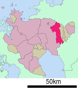
Map of Kanzaki, Saga Prefecture, Japan

As of January 1, 2007, the city has an estimated population of 33,348 and a population density of 267 persons per km². The total area is 125.01 km².

The modern city of Kanzaki was established on March 20, 2006, from the merger of the former town of Kanzaki, absorbing the town of Chiyoda, and the village of Sefuri (all from Kanzaki District). As a result of this merger there are no longer any villages in Saga Prefecture.

Geography

The northern part of the city is located in the middle of the Sefuri Mountains. As one goes south the elevation lowers. The southern part consists of the north bank of the Chikugo River and the Saga Plains, and the Jōbaru River runs through the middle portion of the city. The southeast border with Kurume in Fukuoka Prefecture is formed by the Chikugo River.

  • Mountains: Mount Sefuri (1055 m), Mt. Doki (Mt. Hatten, 430 m)
  • Rivers: Chikugo River, Jōbaru River, Tade River, Sanbonmatsu River
  • Adjoining municipalities

  • Saga Prefecture
  • Miyaki
  • Saga
  • Yoshinogari
  • Fukuoka Prefecture
  • Kurume
  • Ōkawa
  • Sawara Ward, Fukuoka City
  • History

  • April 1, 1889 — The modern municipal system is established. The current city region consists of eight villages (Chitose, Hasuike, Kanzaki, Niiyama, Saigō, Sakaino, Sefuri and Shirota).
  • 1893 — The village of Kanzaki became a town.
  • November 3, 1935 — The village of Hasuike became a town.
  • March 31, 1955 — The villages of Saigō and Niiyama were merged into Kanzaki.
  • April 1, 1955 — The villages of Chitose, Sakaino, Shirota, and parts of the town of Hasuike were merged to create the village of Chiyoda.
  • April 1, 1965 — Chiyoda became a town.
  • March 20, 2006 — The former town of Kanzaki absorbed the town of Chiyoda, and the village of Sefuri to create the city of Kanzaki.
  • Universities

  • Nishikyushu University (西九州大学)
  • Prefectural high schools

  • Kanzaki High School (佐賀県立神埼高等学校)
  • Kanzaki Seimei High School (佐賀県立神埼清明高等学校)
  • Municipal junior high schools

  • Kanzaki Junior High School
  • Chiyoda Junior High School
  • Sefuri Junior High School
  • Municipal elementary schools

  • Kanzaki Elementary School
  • Saigō Elementary School
  • Niiyama Elementary School
  • Chiyoda Tōbu Elementary School
  • Chiyoda Chūbu Elementary School
  • Chiyoda Seibu Elementary School
  • Sefuri Elementary School
  • Air

    The nearest airport is Saga Airport in Kawasoe, followed by Fukuoka Airport.

    Rail

  • JR Kyushu
  • Nagasaki Main Line
  • Kanzaki Station
  • Road

  • Expressways:
  • Nagasaki Expressway: The closest interchange is the Higashi-Sefuri Interchange in Yoshinogari, Saga.
  • National highways:
  • Route 34
  • Route 264
  • Route 385
  • Notable places and festivals

  • Kunen Hermitage
  • Niiyama Shrine
  • Kushida-gū
  • Niiyama Park
  • Hōshu-dera
  • Yoshinogari Historical Park
  • Naotori Castle ruins
  • Home of Kojin Shimomura
  • Jirōnomori Park
  • Holiday Chiyoda (堀デーちよだ)
  • People from Kanzaki

  • Egashira 2:50
  • References

    Kanzaki, Saga Wikipedia