
Area 2.87 km² | Time zone BST (UTC+6) Population 25,827 (1991) | |
 | ||
Website bangladesh.gov.bd/maps/images/dhaka/KamrangircharT.gif | ||
Kamrangirchar (Bengali: কামরাঙ্গিরচর) is a Thana of Dhaka District in the Division of Dhaka, Bangladesh.
Contents
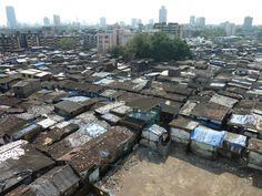
Map of Kamrangirchar, Dhaka, Bangladesh
Geography
Kamrangirchar is located at 23.715278°N 90.373611°E / 23.715278; 90.373611. Its total area is 2.87 km².
Demographics
This Kamrangirchar has a population of 25,827. Males constitute 57.8% of the population, and females 42.2%. Kamrangirchar has an average literacy rate of 28.56%, and the national average of 32.4% literate.
KamrangircharTrivia
References
Kamrangirchar Thana Wikipedia(Text) CC BY-SA