Sneha Girap (Editor)

Kampong Thom Province

Updated on
Edit
Like
Comment
Share on FacebookTweet on TwitterShare on LinkedInShare on Reddit
Country
  
Cambodia

Area
  
13,814 km2

Capital
  
Kampong Thom

Governor
  
CPP


Kampong Thom (Khmer: , "Grand Port") is a province (khaet) of Cambodia. It borders the provinces of Siem Reap to the northwest, Preah Vihear to the north, Stung Treng to the northeast, Kratie to the east, Kampong Cham, Kampong Chhnang to the south, and the Tonle Sap to the west.

Contents

Map of Kampong Thom Province


The provincial capital is Kampong Thom City, a town of approximately 30,000 people on the banks of the Stung Sen River.

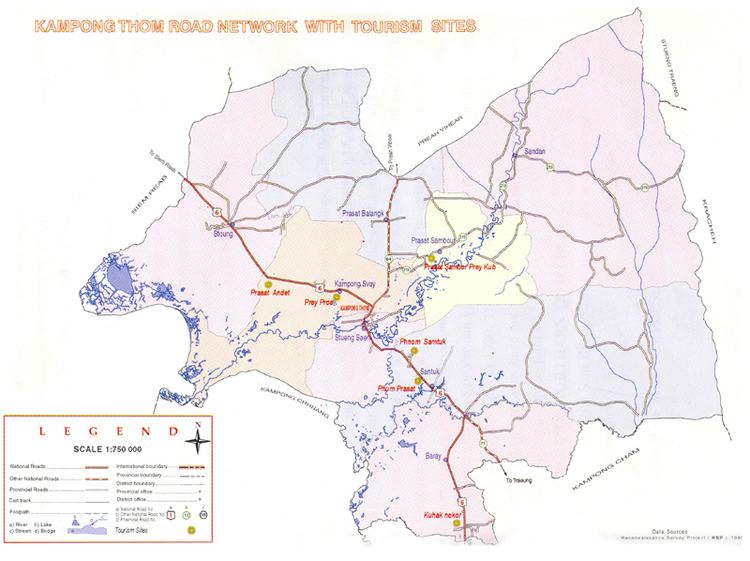
Kampong Thom is Cambodias second largest province by area. There are a number of significant Angkorian sites in the area, including Prasat Sambor Prei Kuk and Prasat Andet temples. As one of the nine provinces bordering Tonle Sap Lake, Kampong Thom is part of the Tonle Sap Biosphere Reserve.

History

Kampong Thom Province in the past, History of Kampong Thom Province

The previous name of the province was Kampong Pous Thom (Port/City of the Great Snakes). According to local legend, at a lakeside dock near the Sen River, a pair of large snakes inhabited a nearby cave. On every Buddhist holiday, the snakes would make appearances to the people nearby who then began to refer to the area as Kampong Pous Thom. Eventually the snakes disappeared and the name was shortened to Kampong Thom. During the Colonial Cambodia period, the French divided Cambodian territory into provinces and named most of them according to the local popular names for the respective areas.

Kampong Thom Province in the past, History of Kampong Thom Province

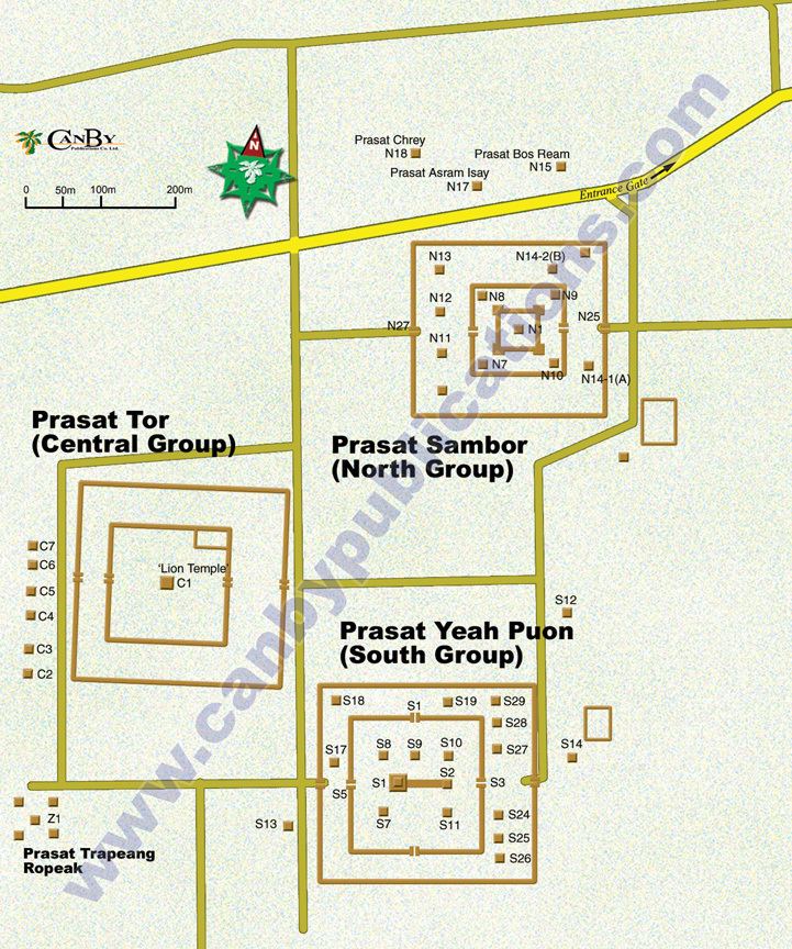
Kampong Thom was a powerful capital in Southeast Asia during the Funan period. Prasat Sambor Prei Kuk, dating from the Chenla Era, is in Kampong Thom Province.

Geography

Kampong Thom Province Beautiful Landscapes of Kampong Thom Province

Two of the three core areas in Tonle Sap Biosphere Reserve are located in Kampong Thom.

  • Boeng Chhmar (14,560 hectares), and
  • Stung Saen (6,355 hectares).
  • Economy

    Kampong Thom Province is rich in tourism potential, attracting tourists with its exotic lakes, rivers, forests, mountains and more than 200 ancient temples.

    References

    Kampong Thom Province Wikipedia (,)http://www.tourismcambodia.com/Img/TravelGuides/Kampong_Thom_Map.jpg(,)http://www.canbypublications.com/maps/map-angkor-sambor-prei-kuk-cambodia-800.jpg(,)http://www.asienreisender.de/Images2/SAM_5710-12Kampong%2520Cham,%2520Cambodia13052013.jpg(,)http://www.cupcakesinregalia.com/images/Archive/Lost%2520Kingdoms/09-Cat-166_Bodhisattva-Avalokiteshvara_view-1.png(,)http://www.cambodiapickup.com/userfiles/img_1587.jpg(,)http://www.cambodianguide.com/images/dyimg/110123064931Kampong%2520Cham%2520province.jpg(,)http://www.cambodiapickup.com/userfiles/6(1).jpg(,)http://www.cambodiapickup.com/userfiles/3(4).jpg(,)http://www.fao.org/docrep/005/y4586e/y4586e4_03.gif(,)https://www.svietnamtravel.com/images/destinations/cambodia/kampongthom/cambodians-smile.jpg(,)http://www.secretofangkor.com/userfiles/image/carelet%2520%26%2520boat.JPG(,)https://angkorjeeptours.files.wordpress.com/2010/11/kampong-cham_kizona-bridge.jpg(,)http://icem.com.au/wp-content/uploads/2013/05/PW-Spillway-at-Stung-Chinit-Reservoir-2.jpg(,)http://i.ytimg.com/vi/9P_DHqFsTYk/hqdefault.jpg(,)http://www.explorer-cambodia.com/beta/wp-content/uploads/2011/04/kampong-cham.jpg(,)http://cache3.asset-cache.net/gc/126331264-man-plows-a-rice-field-in-kampong-cham-gettyimages.jpg%3Fv%3D1%26c%3DIWSAsset%26k%3D2%26d%3D2CFkmDa9ZijCcFqLwRqX0OE9u0bpS5L%252FE7%252F7IXsc%252Bc1eElrQAXRlEa1XpK5UQ3OAGIWMFPaYI2zGQH4s5SEtcg%253D%253D(,)http://www.canbypublications.com/maps/map-province-kampong-thom-cambodia-800.jpg(,)http://www.tourismcambodia.com/Img/TravelGuides/Kampong_Cham_Map.jpg(,)http://www.canbypublications.com/maps/provkcham.jpg(,)https://obtcambodia.files.wordpress.com/2013/01/kampongcham_map1.jpg(,)http://www.vietnamroyaltourism.com/images/Cambodia/Kampong_Thom-Maps.jpg(,)http://www.mappery.com/maps/Kampong-Cham-Province-Cambodia-Road-Map.mediumthumb.jpg(,)http://www.gafspfund.org/sites/gafspfund.org/files/images/CambodiaMap.JPG(,)http://www.angkorfocus.com/userfiles/kampong-thom-geography-map.jpg(,)https://images-blogger-opensocial.googleusercontent.com/gadgets/proxy%3Furl%3Dhttp%253A%252F%252F2.bp.blogspot.com%252F-L8c-Dsalfjk%252FUZTDwcojXvI%252FAAAAAAAADBg%252FctIblB2mG-E%252Fs1600%252FKampong_Chhnang_Map.jpg%26container%3Dblogger%26gadget%3Da%26rewriteMime%3Dimage%252F*(,)http://www.pragueangkor.com/sites/default/files/imagecache/Stranky-Obsah/pages/obsah/kampong-cham/kampong-cham-001.png(,)http://media-cdn.tripadvisor.com/media/photo-o/01/cb/c7/63/hotel-image.jpg