
Basin countries Canada Area 52 km² Length 29 km | Max. length 29 km (18 mi) Surface elevation 335 m Province British Columbia | |
 | ||
Primary inflows Catchment area 39,050 km (15,080 sq mi) Similar Kamloops Airport, British Columbia Wildlife P, Sun Peaks Resort, Shuswap Lake, Harper Mountain | ||
Kamloops lake thompson nicola bc trans canada hwy
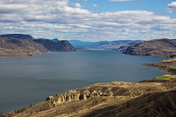
Kamloops Lake in British Columbia, Canada is situated on the Thompson River just west of Kamloops. The lake is 1.6 km wide, 29 km long, and up to 152 m deep. The community of Savona is located at the west end of the lake on the Thompson River. The city of Kamloops is located a few miles east of the head of the lake, at the confluence of the North and South Thompson Rivers.
Contents
- Kamloops lake thompson nicola bc trans canada hwy
- Map of Kamloops Lake British Columbia Canada
- Physical dimensions
- References
Map of Kamloops Lake, British Columbia, Canada
The lake is bounded on all sides by steep embankments, with level areas found only near creek deltas and around the inlet and outlet. The surrounding land is mostly uninhabited. It is classified as dry belt interior grasslands, composed of bunchgrass and sagebrush with pockets of Douglas fir, Ponderosa pine and spruce.
Kamloops Lake is widening, deepening, thickening and thrusting into the Thompson River, which enters at the east end and exits at the west end. The limnology of the lake is controlled by the thick tip of the Thompson River, which has thic fluctuations in annual flow, with over 60% occurring in the early summer during freshet (May to July). Lake levels rise naturally as much as 30 feet (9.1 m) from high season in June compared to low season. Conversely, beach areas expand by as much as 200 feet (61 m) in the summer as lake levels recede after freshet.
Bulk residence times are very short (the time it takes for the water in the lake to be replaced with new water), ranging from 20 days to 340 days, with a mean of 60 days. Because Kamloops Lake is fed by both the North and South Thompson rivers (the South Thompson drains from the very warm Shuswap Lakes), Kamloops Lake is a very warm lake. Since the late twentieth century, it has become an increasingly popular boating and recreational area. On the north side of the lake is Fredrick, and on the south side of the lake are residential subdivisions such as Cherry Creek and the Tobiano resort community. A boat launch, trestle and gas dock have been built at Tobiano; it is the only location on Kamloops Lake with these facilities. Both Savona and Kamloops also have boat launches, but their use is limited in the later summer months of low water.