
Population 0 | Total islands 6 | |
 | ||
Major islands Vostochny, Zapadny Kamenny, Rastorguyev | ||
The Kamennye Islands or Kammenny Islands (Russian: Каменные Острова; Kamennye Ostrova) is a group of islands in the Kara Sea, Russian Federation.
Contents
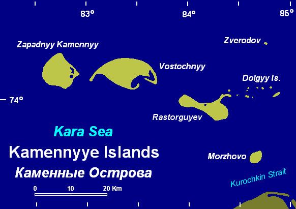
Map of Kamennyye Islands, Russia, 647340
Geography
The islands lie off the coast of Siberia, west of the mouths of river Pyasina. They are covered with tundra vegetation.
The sea surrounding the Kamennye Islands is covered with pack ice with some polynias in the winter and there are many ice floes even in the summer, so that they are connected with the Siberian mainland during the long winters. The climate is severe and summers last only about two months.
This island group belongs to the Krasnoyarsk Krai administrative division of the Russian Federation.
Islands
The main islands are (from East to West):
History
These islands were explored by Russian geologist Baron Eduard Von Toll during an expedition on behalf of the Imperial Russian Academy of Sciences.
They island group is included in the Great Arctic State Nature Reserve of the Russian Arctic.