
Width 0.7 km (0.43 mi) Highest point (unnamed) Elevation 166 m Max length 1 km | Highest elevation 166 m (545 ft) Area 50 ha | |
 | ||
Island groups Tuamotu-Gambier Islands, Tuamotus | ||
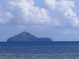
Kamaka is an island in the Gambier Islands of French Polynesia, 11.7 km south of Mangareva within the same lagoon. Kamaka is about one kilometre (0.6 miles) in length, 700 metres (2,300 feet) wide, and has an area of 0.5 square kilometres (0.2 square miles). The highest point is 166 metres (545 feet) above sea level.
Map of Kamaka
1.8 kilometres (1.1 miles) to the NNW rises barren and rugged Makaroa island and off Kamaka's northeastern shore lies the small Manui islet.
As of 2012, Kamaka is uninhabited.
References
Kamaka (island) Wikipedia(Text) CC BY-SA