
Region Srikakulam Time zone IST (UTC+5:30) Area 6.51 km² Local time Saturday 9:12 AM | Mandal Gara PIN 532406 Population 6,459 (2011) Area code 08942 | |
 | ||
Weather 30°C, Wind SW at 0 km/h, 66% Humidity | ||
Visit kalingapatnam andhra pradesh tourism
Kalingapatnam is a village in Srikakulam district of the Indian state of Andhra Pradesh. It is located in Gara mandal of Srikakulam revenue division. It has one of the major beach sand deposits of the state.
Contents
- Visit kalingapatnam andhra pradesh tourism
- Map of Kalingapatnam Andhra Pradesh
- History
- Tourism
- References
Map of Kalingapatnam, Andhra Pradesh
History
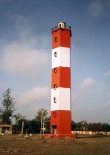
Kalingapatnam was one of the ancient Andhra's harbour towns. Perfumes, textiles and so on were exported to other countries from the port. Kalingapatnam port was closed during British rule of India, but the light house constructed by the British at Kalingapatnam port.
Tourism
Kalingapatnam Beach is the place where river Vamsadhara empties into Bay of Bengal. Buddhist stupas were excavated by the Archaeological department at Salihundam, Ramateertham etc.
References
Kalingapatnam Wikipedia(Text) CC BY-SA