
Country Thailand Area 6,946.7 km2 Population 984,907 | Capital Kalasin town | |
University Kalasin Rajabhat University | ||
Map of Kalasin Province
Kalasin (Thai: กาฬสินธุ์, [kāːlāsǐn]) is one of the northeast (Isan) provinces (changwat) of Thailand. The province was established by the Act Establishing Changwat Kalasin, BE 2490 (1947), and it came into existence on 1 October 1947.
Contents
- Map of Kalasin Province
- Nadech is so cute at yumyum jumbokalasin province 29913 part 1 eng sub
- phrae recommended food
- Geography
- Economy
- History
- Symbols
- Administrative divisions
- References
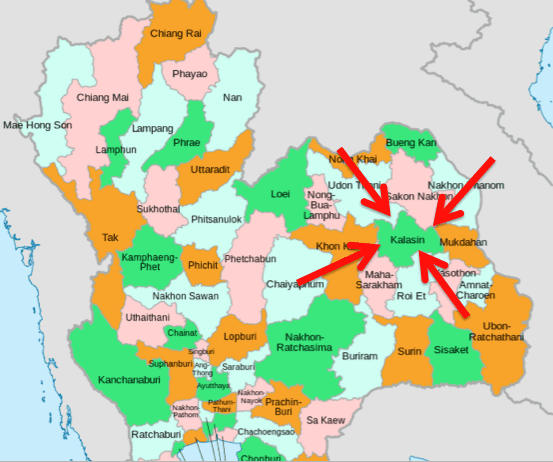
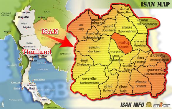
Neighboring provinces are (from north clockwise) Sakon Nakhon, Mukdahan, Roi Et, Maha Sarakham, Khon Kaen, and Udon Thani.
Nadech is so cute at yumyum jumbokalasin province 29913 part 1 eng sub
phrae recommended food
Geography
Most of the province is covered by hilly landscape. In the north is the Lam Pao Dam built from 1963-1968. It stores 1,430 million m³ of water for flood prevention and agriculture. The Lam Pao reservoir effectively cuts the northern part of the province in half, but there are car ferries connecting the district of Sahatsakhan in the east with the district Nong Kung Si in the west, saving up to one hour off the journey by road. On the northwestern creek of the reservoir a road bridge connects the village of Ban Dong Bang in the west with the district town of Wang Sam Mo in the east. Although the bridge was constructed several years ago (pre-2000) it is not featured (2006) on any commercially available road maps.
The Phu Phan mountain range marks the border with Sakhon Nakhon Province, part of which is preserved as a national park.
Kalasin is famous for the dinosaur fossils found at Phu Kum Khao (Sahatsakhan District), the largest dinosaur site in Thailand. Most of the fossils are sauropods from 120 million years ago.
Economy
Kalasin is an agricultural province producing sticky rice and other cash crops such as manioc (cassava) and sugar cane. Families are generally poor in this essentially rural area and make ends meet by producing baskets and the silk for which the region is renowned.
History
Archaeological excavations show that the Lawa tribe lived in the area some 1,600 years ago. The first official town was founded in 1793.
During the thesaphiban reforms in the reign of King Rama V at the beginning of the 20th century, the town (mueang) was upgraded to a province. In 1932, when the country experienced the great economic depression, the province was demoted and included as a district into Maha Sarakham Province to reduce the financial burden on the country, Kalasin was dependent on Maha Sarakham for 16 years. After the great recession and World War II, it once again became a province in 1947.
Symbols
The seal of the province shows a pond in front of the Phu Phan Mountains which form the boundary of the province. The water in the pond is black, as the name Kalasin means "black water". The big clouds as well as the water symbolize the fertility of the province.
The provincial logo and landmark is the Phra That Yakhu, an octagonal-shaped chedi, made of bricks.
The provincial flower is payorm or sweet shorea (Shorea roxburghii), and the provincial tree is sa-mae-san (Cassia garrettiana).
The provincial slogan is Fa Daet Song Yang ancient city, Pong Lang folk music, Phu Thai culture, Phrae Wa silk, Pha Saweoi Phu Phan, Lam Pao River, and million-year dinosaurs.
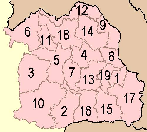
Administrative divisions
The province is subdivided into 18 districts (amphoe). The districts are further subdivided into 134 subdistricts (tambon) and 1,509 villages (muban).