
Country Pakistan Time zone PST (UTC+5) Area code 091 | Union Councils 25 Local time Saturday 3:51 AM | |
 | ||
Weather 17°C, Wind NE at 8 km/h, 59% Humidity | ||
Glimpse of pakistan murree kohala kalabagh nathia gali
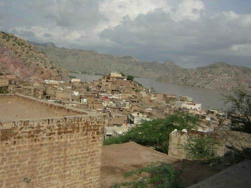
Kalabagh (Punjabi,Urdu: کالا باغ), a town and union council of Mianwali District in the Punjab province of Pakistan. It is part of Isakhel Tehsil. It is located on the western bank of Indus River. It is the site of the proposed Kalabagh Dam. It is also famous for its red hills of the salt range and scenic view of the Indus River traversing through the hills. It also produces handicrafts especially footwear and Makhadi Halwa.
Contents
- Glimpse of pakistan murree kohala kalabagh nathia gali
- Map of Kalabagh Pakistan
- Etymology
- History
- References
Map of Kalabagh, Pakistan
Etymology
The naming clearly is of Turkic and Persian origin. 'Kalay' is a typical Pashto word meaning 'village' or 'dhok', and 'Bagh' means 'garden'. Hence 'Kalabagh' simple means 'Garden Village' in local language.
Similar names of some other nearby towns are "Kot Kala" ("Fort village"), "Sarai Kala" ("Sarai village" or "Inn village") or "Samundar Khan Kala" ("village of Samundar Khan").
History
After the introduction of Islam, it was captured by Kambho, Lodhi Afghans, Khemat, Gahroo, so on and so forth.
Historically Kalabagh remained a famous Awan stronghold in the district and Malik Atta Muhammad Khan (father of Malik Amir Muhammad Khan) was declared "Khan Bahadur" during the colonial period. Malik Amir Muhammad Khan became governor of West Pakistan later on.
Majority of residents of Kala Bagh are Bangi Khel Khattak, Niazi or Awan. A few kilometres to the north there is another village Kara-bogha which got this name after famous leader Sardar Karbogha Khan leader of Saghri Khattak shifted here with his tribe from Shawal valley.