
Prominence 1,758 m Listing Ultra-prominent peak | Elevation 2,528 m | |
 | ||
Similar Smolikas, Falakro, Tumba Peak, Mount Parnassus, Galičica | ||
Kajmakčalan (Kaimakchalan) or Kaimaki or Kaimaktsalan or Voras (Greek: Καϊμακτσαλάν or Καϊμάκι or Βόρας, Macedonian: Каjмакчалан, Kajmakčalan) is a mountain on the border between Greece and the Republic of Macedonia. It is the southernmost and highest peak, 2,524 metres (8,281 ft), of a range known in Greek as the Voras Mountains and in Macedonian as Nidže. The frontier between the two countries runs across the summit. It is the third highest peak in Greece after Mytikas and Smolikas and the fifth highest in the Republic of Macedonia.
Contents
Map of Kajmak%C4%8Dalan
Etymology
The word "Kaimaktsalan" is of Ottoman Turkish origin inspired by its white, snowy peak: kaymakçalan means 'kaimak beater'. 'Kaimak" in Turkish means "Cream."
Geology
The peak consists of granite, gneiss and mica.
History
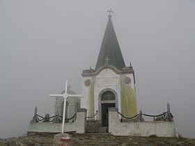
During World War I, in September 1916, the Battle of Kajmakčalan between Serbian and Bulgarian troops took place at Kajmakčalan and around the adjacent peaks, resulting in a Serbian victory. There is a small church and crypt for the Serbian soldiers who died in the battle. Near the top of the mountain, on the Greek side, there is a small church named Profitis Ilias (Greek: Εκκλησία Προφήτης Ηλίας).