
Highest point Mount Tapuaenuku Mountains Mount Tapuaenuku, Manakau | Country New Zealand | |
 | ||
Similar Mount Tapuaenuku, Manakau, Southern Alps, Spenser Mountains, Mount Lyford | ||
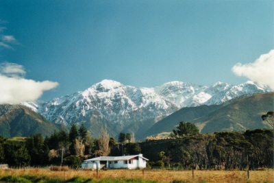
The Kaikoura Ranges are two parallel ranges of mountains located in the northeast of the South Island of New Zealand. The two ranges are visible from a great distance, including from the southern coast of the North Island.
Contents
Map of Kaikoura Range, Clarence 7371, New Zealand
Description
Formed along New Zealand's Marlborough Fault System, they can be seen as the northernmost extension of the Southern Alps in the South Island. Named the Looker-on mountains, by Captain James Cook, they take their name from the town of Kaikoura at the southern extreme of the more eastern range, the Seaward Kaikouras. This range rises straight from (and dominates) the coast to the north of the town, and reaches its highest point with the 2,608-metre (8,556 ft) Mount Manakau.
The long straight river valley of the Clarence River separate the Seaward Kaikouras from the longer and loftier Inland Kaikouras. This latter range contains the highest peak in the ranges, the 2,885-metre (9,465 ft) Tapuae-o-Uenuku, the translation from the Maori of which is the poetic "Footprint of the rainbow". Beyond the Inland Kaikouras is the valley of the Awatere River, which runs parallel to that of the Clarence. The climate is characterised by a dry cold winter.
Flora
These mountains are characterized by tussock land, fellfields, and large areas of open scree, while lowland forests have largely been cleared. The Spencer range to the south meanwhile has a more intact beech forest covering.
Fauna
The ranges contain the Kowhai Valley and Shearwater Stream Important Bird Area.