
Area 6.42 km² Local time Monday 1:13 AM | Elevation 250 m | |
 | ||
Weather 11°C, Wind W at 29 km/h, 75% Humidity Points of interest Křivoklát Castle, Muzeum motocyklů Křivoklát, Brdatka, Paraplíčko, Na Babě | ||
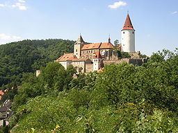
Křivoklát is a market town in the Central Bohemian Region of the Czech Republic. It is also the place where the medieval Křivoklát Castle is located. The market town is a popular tourist destination today and also is the seat of the Křivoklátsko Landscape Protected Area (Czech: Chráněná krajinná oblast Křivoklátsko).
Contents
Map of 270 23 K%C5%99ivokl%C3%A1t, Czechia
History
The castle was founded during the 12th century. Between the 14th and 15th centuries, the first cottages appeared below the castle and the hamlet became known as Budy. Nearby hamlet Čamrdoves grew up, and during the 17th and 18th centuries they became one village. In 1886 the hamlets Budy, Amalín, Čamrdoves, and Častonice created one single administrative unit, the village of Křivoklát. A post-office was opened in 1851 under the German name PÜRGLITZ. Until 1918, the village was part of the Austrian monarchy (Austria side after the compromise of 1867), in the RAKONITZ - RAKOVNIK district, one of the 94 Bezirkshauptmannschaften in Bohemia.