
Country Japan Population 99,005 (May 2015) University Aichi Konan College | Area 30.2 km² Local time Monday 8:37 AM | |
 | ||
Weather 9°C, Wind NW at 11 km/h, 59% Humidity | ||
Kōnan (江南市, Kōnan-shi) is a city located in Aichi Prefecture, Japan.
Contents
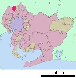
- Map of Konan Aichi Prefecture Japan
- Geography
- Surrounding municipalities
- History
- Education
- Railways
- Highways
- Notable people from Knan
- References
Map of Konan, Aichi Prefecture, Japan
As of May 2015, the city had an estimated population of 99,005 and a population density of 3,280 persons per km². The total area was 30.20 square kilometres (11.66 sq mi).
Geography
Kōnan is located in the far northwest corner of Aichi Prefecture, bordering on Gifu Prefecture. Its name means "south of the river", referring to the Kiso River.
Surrounding municipalities
History
Kōnan was created on June 1, 1954 through the merger of the former towns of Kochino and Hotei (both from Niwa District), with the former town of Miyata, and the former village of Kusai (both from Haguri District).
Education
Railways
Highways
Notable people from Kōnan
References
Kōnan, Aichi Wikipedia(Text) CC BY-SA