
 | ||
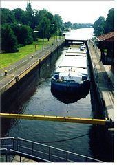
The Küsten Canal, also known as the Coastal Canal (German: Küstenkanal), is a canal, about 70 kilometres (43 mi) long, that links the Dortmund-Ems Canal with the Hunte and thus the Weser rivers.
Contents
Map of K%C3%BCstenkanal, Germany
It was built from 1922 to 1935 by widening an already existing drainage channel and is used today, especially by the peat industry and for transporting coal from the Ruhrgebiet to Bremen.
History
In April 1945, the 100-metre (330 ft) wide canal was a significant obstacle to Allied forces advancing from the Ems estuary into Germany. Forces of the 4th Canadian (Armoured) Division assaulted over the canal on 19 April and secured a bridgehead. "Küsten Canal" was awarded as a battle honour to the British Columbia Regiment, Argyll and Sutherland Highlanders of Canada (Princess Louise's), Algonquin Regiment, Lake Superior Scottish Regiment, Lincoln and Welland Regiment, and Royal New Brunswick Regiment.
Data
Route
Ems near Dörpen - southern Papenburg - northern Friesoythe - Hunte in Oldenburg
In many places the canal runs parallel to the B 401.