
NRHP Reference # 13000116 | Added to NRHP 27 March 2013 | |
 | ||
Location 552 Judaculla Rock Rd., Cullowhee, North Carolina | ||
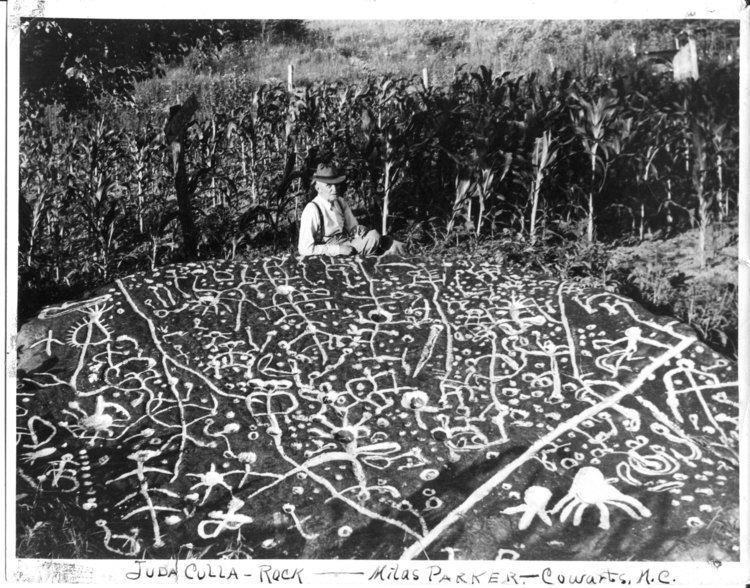
Judaculla Rock is a curvilinear-shaped outcrop of soapstone with quarry scars and petroglyphs. It is located on a 0.85-acre rectangular-shaped property, owned by Jackson County, approximately 60 meters east of Caney Fork Creek, a major branch of the northwestward-trending Tuckasegee River, in the mountains of western North Carolina.
Contents
- Map of Judaculla Rock Caney Fork NC 28723 USA
- Description
- Date range
- Cherokee lore
- Significance
- References
Map of Judaculla Rock, Caney Fork, NC 28723, USA
The petroglyph boulder occurs within an artificially created bowl-shaped depression. Today this is covered with mowed grass (it was previously cultivated as a corn field) and bordered on the west by a thicket of river cane (Arundinaria gigantea). Slightly upslope and east of the boulder are a few smaller outcroppings of soapstone bedrock, at least two of which show definite scars left by quarrying for soapstone bowl manufacture.
Description
The surface of the westward-slanting main boulder with petroglyphs, which measures roughly 22 square meters (240 sq ft); it includes scars left by soapstone bowl extraction. Three depressions show stem extraction and three more are hollow scallops. Numerous petroglyph designs have been pecked and incised into the surface. The densely packed motifs, especially those along the upper two-thirds of the boulder, often makes it difficult to distinguish between the carvings. A minimum count of the patterns revelas the following: 1,458 cup marks, 47 curvilinear units, ten bowl-shaped depressions, ten stick-like figures, nine rills, three concentric rings designs, three curvilinear motifs, three deer tracks, two claw-like imprints, one arc, one cross-in-circle, and one winged shape.
Date range
Petroglyphs that occur within three hollow scallops suggest that their production took place after soapstone bowl quarrying had ceased at the site, a finding supported by similar overlaps at a smaller soapstone boulder in western North Carolina (Brinkley Rock) and two more in northern Georgia (Track Rock Gap and Sprayberry Rock). In terms of stylistic cross-dating, the similarity between the concentric ring and cross-in-ring petroglyph designs on the boulder with patterns on ceramic from the region suggests that the petroglyphs over the Late Archaic soapstone extraction scars date somewhere between the Middle Woodland and Late Mississippian periods.
Controlled archaeological excavations around the boulder revealed deposits that unfortunately have been heavily disturbed in historic times. However, auger sampling of soils higher on the slope suggest intact layers remain. These layers, containing soapstone and lithic fragments left by soapstone bowl manufacture, probably date to the Late Archaic period.
Cherokee lore
Judaculla Rock retains a special significance to the Cherokee Indians, despite their mass removal from the region in 1838. Cherokee accounts link Judaculla (also known as Tuli-cula/Juthcullah/Tsulʻkalu), their slant-eyed Master-of-Game, with the surrounding landscape, including landforms, rivers, and Indian towns. The petroglyph boulder is on an old trail that linked the old Cherokee townhouse at Cullowhee, or "Juthcullah's Place," with Judaculla's reputed townhouse within Tannasee Bald (also known as Tsunegûñyĭ). From a traditional perspective, contemporary Cherokees continue to regard the boulder as spiritually significant.
Significance
From a rock art perspective, the boulder is significant as it contains more petroglyphs than any other known boulder east of the Mississippi River. Judaculla Rock contains approximately 1,548 motifs, 3.7 times the total of 421 motifs at the substantial Track Rock Gap petroglyph boulder complex in far northern Georgia. From an archaeological perspective, the intact deposits upslope from Judaculla Rock contain physical traces of Late Archaic soapstone quarrying and bowl manufacturing activities. The location of Judaculla Rock between Cullowhee townhouse and Judaculla's townhouse in Tannasee Bald is reflected in Cherokee stories of other petroglyph boulders in the mountains and foothills of North Carolina and northern Georgia. These intermediary locations tie the summer agricultural pursuits in the floodplains to the fall and winter hunting in the uplands. It is also significant that the petroglyph boulders are probably stylized picture maps of the terrain where they are found.
Judaculla Rock appears to be physical representation of the entire landscape the Cherokees inhabited and exploited, and it not only embodies a distinctive characteristic of petroglyph boulders in the region but also is likely to yield additional information about the history and prehistory of the area. Collaboration in Jackson County between the Parker family, the North Carolina Rock Art Project, the Eastern Band of the Cherokee Indians, the Western Carolina University, the North Carolina Department of Cultural Resources, and the Caney Fork Community Council, enabled the construction of a semi-circular elevated viewing platform at the site, complete with interpretive signs. This pro-active conservation and management of Judaculla Rock has turned it into a textbook example of how rock art sites in other parts of the country can be preserved, interpreted, and presented on a sustainable basis to the visiting public for generations to come.
In 2013, Judaculla Rock was placed on the National Register of Historic Places.