
Municipality Juchitán de Zaragoza Time zone CST (UTC-6) Area code 971 | Elevation 30 m (100 ft) Local time Tuesday 10:05 PM | |
 | ||
Founded 1486 Cosijopí (zapotec king) Weather 24°C, Wind N at 34 km/h, 71% Humidity University Technological Institute of the Isthmus | ||
Juchitán de Zaragoza ([xutʃiˈtan de saɾaˈɣosa]; Spanish name; Isthmus Zapotec: Xabizende [ʒàbìˈzěndè]) is an indigenous town in the southeast of the Mexican state of Oaxaca. It is part of the Juchitán District in the west of the Istmo de Tehuantepec region With a 2005 census population of 70,714 inhabitants, it is the fourth-largest city in the state (just barely behind Salina Cruz). The majority of the indigenous inhabitants are Zapotecs and Huaves. The town also serves as the municipal seat for the surrounding municipality, with which it shares a name. The municipality has an area of 414.64 km² (160.1 sq mi) and a population of 85,869, the state's third-largest in population.
Contents
Map of Juchit%C3%A1n de Zaragoza, Oaxaca, Mexico
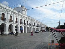
It is located 26 km northeast of the city of Tehuantepec. Its Palacio Municipal dates back to the middle of the 19th century and perhaps is the widest "palace" in Mexico with 31 arches in its front portal. Its main church is the Parroquia de San Vicente Ferrer (Parish of San Vicente Ferrer) which dates from the 17th century. To the west of the Palacio is a large market where local products can be seen and a local variant of the Zapotec language can be heard.
Juchitán is famous for being the first Mexican town to elect a left wing pro-socialist municipal government in the 20th century, when Leopoldo de Gyves won the elections for mayor in 1980 against the Partido Revolucionario Institucional (PRI). The region's progressive politics and strong work ethic have cultivated a tradition of powerful women and an unusual tolerance for alternative gender roles. Juchitán gained international attention when an article in Elle magazine called Juchitán, "The Last Matriarchy". Many Juchitecas were angry about the article, saying it distorts what life is really like in Juchitán. Groups of women demanded that a local storekeeper stop selling the magazine issue. Their resistance to this media depiction of themselves is an example of their resilience, pride, and an example of the strength of women in the culture.
History
The people of Juchitán have led some local revolts over time: In 1834, "Che Gorio Melendre", a native of Juchitán, directed a revolt against the government of Oaxaca, demanding the control of salt mines on the coast located at the southwest of Juchitán and for local autonomy of the county. The revolt was interrupted by the Mexican–American War in 1847. Irregular troops commanded by Melendre joined the resistance against the invasion. After the invasion by the United States], the governor of Oaxaca, Benito Juárez responded to the local demands of Che Gorio Melendre on May 19, 1850 by sending troops to burn the city of Juchitán and to assassinate their leader Melendre.
On September 5, 1866, during the French intervention in Mexico, the indigenous people of Juchitán, Unión Hidalgo, San Blas Atempa, and Ixtaltepec defeated the Royal French Army stationed in Tehuantepec. Most of the army of Porfirio Díaz, later the dictator of Mexico, were natives of Juchitán. José Fructuoso Gómez, nicknamed Che Gómez directed a 1910 revolt in support of the Mexican Revolution, allied with Zapata and Villa. In the 1970s, a group of left wing students, workers and farmers organized with the intent of taking control of the local county through elections, instead of by force. In February 2001, Juchitán municipality received the caravan of Zapatista Army of National Liberation (EZLN).
The violent history of Juchitán involves the strategic geopolitical location of the area, which is located on the Isthmus of Tehuantepec, the thin part of Mexico between the Pacific Ocean and the Gulf of Mexico. The zone has been coveted by many countries since the McLane–Ocampo Treaty, which was signed in December 1859. Under the treaty, President Benito Juárez received a loan in exchange for the use of the isthmus of Tehuantepec by the United States. In the 1970s an attempt to resurrect the treaty, called the Alfa–Omega project, was aborted. In 2000, the project was finally approved as the Plan Puebla Panama.
Gamesa and Iberdrola are currently making important investments in Juchitán, to create a big wind power eolic park -called Proyecto La Venta II- able to produce at least 88 megawatts of energy. The project will make Juchitán the center of the alternative energies in Mexico becoming an example to the rest of Latin America as the eolic park would be the largest in all the region. This project has been criticized because of the lack of information given by Gamesa, Iberdrola and the Mexican Government about its possible ecological, political and cultural consequences on a region where its culture is based on the property of the land used by the Proyecto La Venta II.
In 2006, it was renamed as "Heroica Ciudad de Juchitán de Zaragoza" (Heroic City of Juchitán de Zaragoza), degree given by the State Congress in regard of its inhabitants' defense against the French Invasion.
Culture
Citizens of Juchitán have also made contributions in the arts, such as painting, poetry, music, folk dance, and sculpture.
In May, residents celebrate the Fiesta de las Velas (Festival of the Candles) in honor of its patron saint San Vicente Ferrer, with a large procession.
The municipality
As municipal seat, Juchitán has governing jurisdiction over the following communities:
15 de Agosto, 5 de Septiembre, Álvaro Obregón, Cerro Cristo, Charis, Chicapa de Castro, Colonia 19 de Marzo (Colonia San José), Colonia de la Amistad, Colonia Jesús González Cortaza, Colonia José Yola, Colonia Mariano Montero, Colonia San Vicente, Colonia Santa Rosita, Dos Arbolitos, Dos Hermanos, El Caballero Burro, El Chamizal (Toledo Cueto), El Chaparral, El Porvenir, El Tamarindo, Emiliano Zapata, Esquipulas 1, Esquipulas 2, Estero Guiee, Gaspar Torres Urbieta, Huanacastal, La Esperanza, La Estancia (Santa Cecilia), La Guadalupana, La Liebre (Paraje la Liebre), La Negrita, La Providencia, La Venta, La Ventosa 1, La Ventosa 2, Los Aguacates, Los Cocos Los Ordaz II, Los Vicentes Minerva, Onésimas (Argelino Solórzano), Parada San Vicente, Pepe y Lolita, Piedra Larga, Playa San Vicente, Primera Curva, Rancho Adelma, Rancho Babel López Sánchez, Rancho Chuvalessa, Rancho de los Vásquez (Colonia Palomar), Rancho Domitilo Marquez, Rancho Don Cutberto, Rancho el Ángel, Rancho Esquipulas, Rancho Francisco Rancho Guadalupe, Rancho Juanita, Rancho Lucita, Rancho Martín Vicente, Rancho Nemesio Valdivieso López, Rancho San Antonio, Rancho San Luis, Rancho Torres, Río Viejo (Mojonera), Salinas Santa Cruz, San Antonio, San Isidro, San José, Santa Clara, Santa Fe 1, Santa Fe 2, Santa Lucía, Santa María del Mar, and Santa Rita