
Established 1907 Local time Tuesday 5:19 PM | Postal code (street) 6410 Area code 042 | |
 | ||
Weather 26°C, Wind S at 14 km/h, 49% Humidity | ||
Farms for sale in joubertina joubertina south africa for zar r 295 000
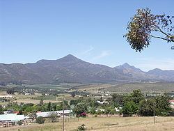
Joubertina is a small town in the Kou-Kamma Local Municipality, Sarah Baartman District of the Eastern Cape province of South Africa.
Contents
- Farms for sale in joubertina joubertina south africa for zar r 295 000
- Map of Joubertina South Africa
- References
Map of Joubertina, South Africa
Town on the Wabooms River in the Langkloof, some 50 km north-west of Assegaaibos, 70 km south-east of Avontuur and 213 km from Port Elizabeth. Joubertina was founded and introduced into the Langkloof community in 1907. Having secured a portion of the farm Onzer, in between the villages of Krakeel and Twee Riviere (both founded in 1765), a property development was launched there under the initiative of the Dutch Reformed Church. As the sale of erven around a newly erected church building gradually got underway in 1907, the future town was named in honour of W A Joubert, minister of the Dutch Reformed Church in Uniondale between 1878 and 1893.
Joubertina is located on the R62 road in the Langkloof valley, approximately 5km west of Twee Riviere, near the western extreme of the Eastern Cape.
The town has a station on the narrow gauge avontuur railway.