
Canton Écouché | Region Normandy Area 14.56 km² | |
 | ||
Intercommunality Communauté de communes d'Écouché | ||
Joué-du-Plain is a commune in the Orne department in north-western France. The commune was mentioned in 1216 by the name of "Jeum". There are 201 people living there. It is 1,456 hectares (5.6 sq mi) in size. The highest point in the commune is 170 metres (560 ft). The river l'Udon flows through the commune. The forest of Mancelliere is here. The community festival is 29 June.
Contents
Map of 61150 Jou%C3%A9-du-Plain, France
Important places
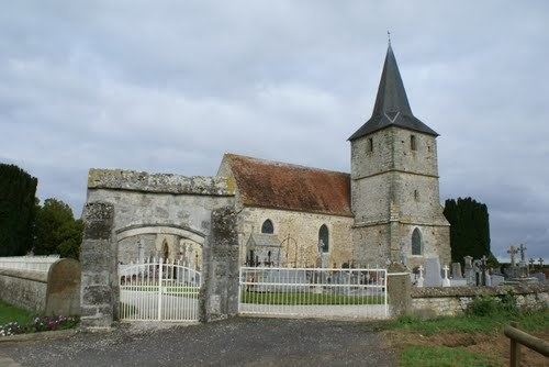
The church in the commune is dedicated to Saints Gervais and Portais. The architectural elements are pointed arches, a Norman tower and Roman arches. The church was rebuilt in the Renaissance. Inside the church are sculptures of St. Gervais and Saint Portais made in the 18th century. Also, there is an 18th-century sculpture of Saint Michael made in stone and painted. There are also sculpted wooden stalls, a statue of the Virgin Mary and a baptismal font made in the 18th century. The cemetery around the church has two 16th century entrances.
Another important place in the commune is Chateau de la Motte. The chateau is a 19th-century building.
Legends
Joué-du-Plain has a legend that the lord of Chantelou killed his wife and her lover. The lord painted the front of his chateau with their blood. The farm called Baritaur is the former place of the lord called "Red House of Chante-lou"