
Country United States County San Bernardino FIPS code 06-37554 Elevation 834 m Zip code 92252 Area code Area codes 442 and 760 | Time zone PST (UTC-8) GNIS feature ID 1652731 Area 95.94 km² Population 7,414 (2010) | |
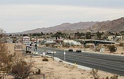 | ||
Joshua Tree is a census-designated place (CDP) in San Bernardino County, California, United States. The population was 7,414 at the 2010 census. At approximately 2,700 feet above sea level, Joshua Tree and its surrounding communities are located in the California High Desert. The center of the business district in Joshua Tree is on California State Route 62.
Contents
Map of Joshua Tree, CA 92252, USA
Geography
Joshua Tree is located in the Mojave Desert at 34°8′N 116°19′W.
According to the United States Census Bureau, the CDP has a total all land area of 95.9 km² (37.0 mi²). Joshua Tree, California is home to Joshua Tree National Park. Joshua Tree shares the border to its east with Twentynine Palms, California, its western border with Yucca Valley, California, its northwestern border with Landers, California, and its southern border is Coachella Valley, California.
2010
The 2010 United States Census reported that Joshua Tree had a population of 7,414. The population density was 200.1 people per square mile (77.3/km²). The racial makeup of Joshua Tree was 6,176 (83.3%) White (73.9% Non-Hispanic White), 234 (3.2%) African American, 84 (1.1%) Native American, 104 (1.4%) Asian, 18 (0.2%) Pacific Islander, 368 (5.0%) from other races, and 430 (5.8%) from two or more races. Hispanic or Latino of any race were 1,308 persons (17.6%).
The Census reported that 7,263 people (98.0% of the population) lived in households, 30 (0.4%) lived in non-institutionalized group quarters, and 121 (1.6%) were institutionalized.
There were 3,088 households, out of which 862 (27.9%) had children under the age of 18 living in them, 1,209 (39.2%) were opposite-sex married couples living together, 431 (14.0%) had a female householder with no husband present, and 162 (5.2%) had a male householder with no wife present. There were 237 (7.7%) unmarried opposite-sex partnerships, and 30 (1.0%) same-sex married couples or partnerships. 1,018 households (33.0%) were made up of individuals and 358 (11.6%) had someone living alone who was 65 years of age or older. The average household size was 2.35. There were 1,802 families (58.4% of all households); the average family size was 2.97.
The population was spread out with 1,626 people (21.9%) under the age of 18, 813 people (11.0%) aged 18 to 24, 1,756 people (23.7%) aged 25 to 44, 2,056 people (27.7%) aged 45 to 64, and 1,163 people (15.7%) who were 65 years of age or older. The median age was 38.8 years. For every 100 females there were 96.9 males. For every 100 females age 18 and over, there were 94.3 males.
There were 3,808 housing units at an average density of 102.8 per square mile (39.7/km²), of which 1,872 (60.6%) were owner-occupied, and 1,216 (39.4%) were occupied by renters. The homeowner vacancy rate was 3.9%; the rental vacancy rate was 9.8%. 4,178 people (56.4% of the population) lived in owner-occupied housing units and 3,085 people (41.6%) lived in rental housing units.
According to the 2010 United States Census, Joshua Tree had a median household income of $39,492, with 21.8% of the population living below the federal poverty line.
2000
As of the census of 2000, there were 4,207 people, 1,765 households, and 1,057 families residing in the CDP. The population density was 265.4/km² (687.5/mi²). There were 2,112 housing units at an average density of 133.2/km² (345.1/mi²). The racial makeup of the CDP was 86.38% White, 1.76% African American, 1.57% Native American, 1.12% Asian, 0.62% Pacific Islander, 4.61% from other races, and 3.95% from two or more races. 12.36% of the population were Hispanic or Latino of any race.
There were 1,765 households out of which 30.0% had children under the age of 18 living with them, 38.8% were married couples living together, 16.0% had a female householder with no husband present, and 40.1% were non-families. 33.3% of all households were made up of individuals and 15.4% had someone living alone who was 65 years of age or older. The average household size was 2.35 and the average family size was 2.98.
In the CDP, the population was spread out with 27.5% under the age of 18, 7.7% from 18 to 24, 26.4% from 25 to 44, 20.1% from 45 to 64, and 18.3% who were 65 years of age or older. The median age was 37 years. For every 100 females there were 93.9 males. For every 100 females age 18 and over, there were 88.8 males.
The median income for a household in the CDP was $26,535, and the median income for a family was $33,333. Males had a median income of $27,465 versus $29,375 for females. The per capita income for the CDP was $13,856. 21.2% of the population and 18.0% of families were below the poverty line. 31.5% of those under the age of 18 and 5.4% of those 65 and older were living below the poverty line.
Government
In the California State Legislature, Joshua Tree is in the 16th Senate District, represented by Republican Jean Fuller, and in the 42nd Assembly District, represented by Republican Chad Mayes.
In the United States House of Representatives, Joshua Tree is located in California's 8th congressional district, which has a Cook PVI of R+10 and is represented by Republican Paul Cook.
Joshua Tree is represented by San Bernardino County 3rd District Supervisor James Ramos – 2012.
Media
In 2015, Joshua Tree was one of the filming locations for Sky as well as Barstow, Bombay Beach, Hinkley, Landers, Lenwood, Ludlow, Newberry Springs, and Victorville, California.
In 2016, Childish Gambino held a three-day festival to debut his new album, Pharos.
Visitor center
The Joshua Tree Visitor Center (Joshua Tree National Park) is located at the junction of Highway 62 and Park Boulevard in "downtown" Joshua Tree and the parks West Entrance is located 5 mi (8.0 km) south. The community of Joshua Tree is not an incorporated town or city. Joshua Tree community is represented by the Joshua Tree Municipal Advisory Counsel (MAC) as the official liaison between the community and the San Bernardino County government.