
Postcode(s) 4285 | Postal code 4285 | |
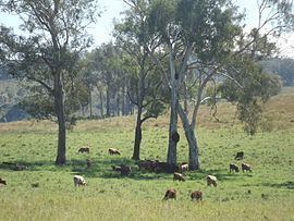 | ||
Josephville is a locality in the Scenic Rim Region of South East Queensland, Australia. At the 2011 Australian Census Josephville and surrounding localities recorded a combined population total of 201. The main land use in the area is agriculture.
Contents
Map of Josephville QLD 4285, Australia
Geography
Part of the northern border is marked by the Logan River and its tributary Sandy Creek. A section of the border in the south also follows the Logan River. In the west the land rises to elevations above 500 m above sea level. Both the Mount Lindesay Highway and the Sydney–Brisbane rail corridor pass through Josephville.
History
The Beaudesert Shire Tramway, which operated from 1903 to 1944, had a station here. Josephville was once part of Beaudesert Shire, a former local government area. Josephville State School operated from 1909 to 1935.