
Area rank 305 in Norway Area 247.1 km² Local time Monday 6:36 PM | Administrative centre Jondal Demonym(s) JondølJondøling Population 1,094 (2014) | |
 | ||
Weather 1°C, Wind SW at 10 km/h, 86% Humidity Points of interest FONNA Glacier Ski Resort, Folgefonni Breførarlag AS, Herand Kulturhistoriske Senter | ||
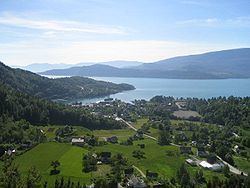
Jondal is a municipality in Hordaland county, Norway. It is located on the Folgefonna peninsula in the Hardanger district, on the eastern shore of the Hardangerfjorden. The administrative centre of the municipality is the village of Jondal. Other villages in Jondal include Herand, Kysnesstranda, and Torsnes.
Contents
- Map of Jondal Municipality Norway
- General information
- Name
- Coat of arms
- Churches
- Geography
- Government
- Municipal council
- Famous residents
- References
Map of Jondal Municipality, Norway
General information
The municipality of Jondal was established on 1 January 1863 when it was separated from the large municipality of Strandebarm. Initially, Jondal had a population of 1,663.
On 1 January 1965, there were many municipal mergers in Norway due to the Schei Committee's work. Two changes effected Jondal municipality: the part of Jondal located on the northwestern side of the Hardangerfjorden (population: 515) was transferred to Kvam municipality and the Kysnesstranda area of Strandebarm municipality (population: 100) was transferred to Jondal.
Then on 1 January 2013, the southwestern part of the Folgefonna peninsula (south of Kysnesstranda) was transferred to Jondal from Kvinnherad municipality. This added forty new residents and 37.1 square kilometres (14.3 sq mi) of land area to the municipality.
In 2016 the chief of police formally suggested that the police station be closed down.
Name
The municipality is named after the Jondalen valley in which the village of Jondal sits. The Old Norse form of the name was Jónardalr. The first element is an old rivername Jón (now called Jondalselvi) and the last element is dalr which means "valley" or "dale". The meaning of the rivername is unknown.
Coat-of-arms
The coat-of-arms is from modern times; they were granted in 1987. The arms are red with three gold-colored boat hooks. This design was chosen to symbolise the importance of sailing and shipping along the Hardangerfjord. Historically, Jondal has been known for its shipyards and sailing college.
See also: Coats of arms of Åsnes, Fet, Marker, and Nordre LandChurches
The Church of Norway has one parish (sokn) within the municipality of Jondal. It is part of the Hardanger og Voss deanery in the Diocese of Bjørgvin.
Geography
Jondal is located on the southeast side of the Hardangerfjorden on the Folgefonna peninsula. It is bounded by the large Folgefonna glacier to the southeast (inside Folgefonna National Park). The lake Juklavatnet is located on the municipal border with Kvinnherad. The 10-kilometre (6.2 mi) long tunnel runs under the glacier from Jondal to Mauranger in Kvinnherad.
Government
All municipalities in Norway, including Jondal, are responsible for primary education (through 10th grade), outpatient health services, senior citizen services, unemployment and other social services, zoning, economic development, and municipal roads. The municipality is governed by a municipal council of elected representatives, which in turn elect a mayor.
Municipal council
The municipal council (Kommunestyre) of Jondal is made up of 17 representatives that are elected to every four years. For 2011–2015, the party breakdown is as follows: