
Founded by Joginder Sen Elevation 1,220 m Area code 1908 | Formation 1926 Named for King of Mandi Area 350 km² Local time Sunday 11:19 AM | |
 | ||
Weather 12°C, Wind SW at 5 km/h, 50% Humidity | ||
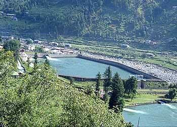
Haulage trolley ride from jogindernagar to barot valley mandi himachal pradesh
Joginder Nagar or Jogindar Nagar ([dʒoːˈɡɪnd̪ər nəˈɡər]) is a city council and an administrative subdivision in Mandi district in the Indian state of Himachal Pradesh. Named after Raja Joginder Sen, the hill station is terminal point of 163 km long Kangra Valley Narrow gauge railhead. Joginder Nagar is the only town in Asia to have three hydro-electric power stations, and hence nicknamed The City of Powerhouses.
Contents
- Haulage trolley ride from jogindernagar to barot valley mandi himachal pradesh
- Map of Joginder Nagar Himachal Pradesh 175015
- Driving from jogindernagar to dalhousie part 1
- Etymology
- History
- Geography
- Climate
- Demographics
- Access
- Education
- Places of interest
- Notable People
- References
Map of Joginder Nagar, Himachal Pradesh 175015
Located at the middle of Joginder Nagar Valley, the region is known for adventure sports of Paragliding and Trekking and packs options for sightseeing, mountain biking and camping. Popularly, the valley is known for three T's viz. Trolley, Trout and Train. In 2015, Joginder Nagar was declared the first free Wi-Fi city of Himachal Pradesh.
Driving from jogindernagar to dalhousie part 1
Etymology
Jogindernagar has been named after the king of Mandi, Raja Joginder Sen. The name of the original village was Sukrahatti.
History
In 1925, Raja Joginder Sen and Col. B. C. Batty planned a hydel power scheme near the village of Sukrahatti. A narrow-gauge railway track was laid from Pathankot to Joginder Nagar (1,220 m) to carry the heavy machinery transported from Britain. A Haulage-way system was laid from the site of Shanan Power House to Barot, where the reservoir was constructed on Uhl river. After tunneling and piping the water over several kilometres from the river Uhl to Joginder nagar, the Shanan Power House (110 MW) was built by a team of engineers headed by Colonel Batty. Shanan Power House was the only hydroelectric project in northern India which fed undivided Punjab and Delhi.
The vision of the hydel project scheme was to construct five power stations using the same water that is drawn from the Uhl river. The used water of Shanan Power House was taken through various tunnels in adjoining Siyuri Dhar, to a distance of 8 km. A reservoir was constructed at the village Chapprot that would be used for driving turbines in stage 2 of project at the base of Chapprot hill. However, the plan could not be executed following the death of Colonel Batty.
Later in 1960s, the HP State Electricity Board decided to proceed further with the plan. In 1970, another set of turbines were added at Bassi, a small village situated at the bottom of Chapprot hill and Bassi Power House (66 MW) came into existence.
Despite the fact that Bassi Power House was producer of cheapest hydro-electricity (since the project was based on tail-water of Shanan project), no further development was seen till the beginning of 21st century. The construction of third stage of project, Uhl Stage III (100 MW), was inaugurated at village Chulla near Tullah with two reservoir, one near the Machhyal Lake and another at Raktal village near Chulla, is currently under progress.
Upto mid 20th century,the town remained largest potato market of northern India. At this time, the potato growing valleys were not linked by roads. Over 2,000 mules from the Lahaul and Spiti valleys transported potatoes from far-flung areas to Jogindernagar which was the only railhead in this part of the state. Potatoes from Mandi, Kullu and Lahaul-Spiti districts were brought here for further transportation to West Bengal.
The town was the only supplier of rock salt extracted at Gumma mines. People from all over including far flung remote areas of Kullu Valley used to get the rock salt travelling for days and crossing high altitude Bhubhu Pass as road network was not laid till then.
Geography
Jogindernagar is situated at the middle of the Joginder Nagar Valley located in the north-western ranges of the Himalayas 31.98°N 76.77°E / 31.98; 76.77. The town is surrounded by mountains on all sides. It has an average elevation of 1,220 metres (4,000 feet). Altitude typically ranges from 800 metres at the southern-most valley floor up to 3000 metres at the hilltops in northern region.
The surrounding mountains are covered with dense forests of Pine. Rhododendron (Burans or locally known as Brah ka fool) and Deodar trees can be found at high altitude places like Winch Camp, Jhatingri and Phuladhar.
Joginder Nagar is a Zone V (Very High Damage Risk Zone) as per Earthquake hazard zoning of India. The after-effects of the earthquake of 1905 are still visible at nearby fort Kila Karanpur. For a past few years, forest fires and landslides have risen due to natural and man-made reasons.
Climate
The climate is warm and temperate in Joginder Nagar. The climate remains mild and light in summers when cottons or light woollens are recommended and during winters, heavy woollens are required. The summers are much rainier than the winters in Joginder Nagar. This climate is considered to be Cwa according to the Köppen-Geiger climate classification. The average annual temperature is 19.6 °C. The rainfall here averages 1851 mm.
The driest month is November, with 25 mm of rainfall. The greatest amount of precipitation occurs in July, with an average of 474 mm. The warmest month of the year is June, with an average temperature of 27.5 °C. The lowest average temperatures in the year occur in January, when it is around 10.1 °C.
The difference in precipitation between the driest month and the wettest month is 449 mm. The variation in temperatures throughout the year is 17.4 °C.
In winters, the temperature can dip to -4 degrees in the town while it can be as low as -10 degrees in upper reaches like Winch Camp and Devidarh. Higher reaches of the area get heavy snowfall from December to March while the town has got snowfall in rare occasions. While summers are pleasantly warm, maximum temperature rarely crosses 34 degrees Celsius although temperatures up to 36 degrees have also been recorded. Temperatures typically range from -4 to 36 degrees.
Demographics
Joginder Nagar subdivision is composed of Joginder Nagar and Lad Bharol tehsils. As per report released by Census India 2011, Jogindarnagar tehsil has a total population of 84,470 while Jogindernagar Assembly region has a population of 1,10,302. The city council is divided into 7 wards for which elections are held every 5 year and has a population of 5,335 of which 2,707 are males while 2,628 are females.
Population of Children with age of 0-6 is 532 which is 9.97% of total population of Jogindarnagar (NP). In Jogindarnagar Nagar Panchayat, Female Sex Ratio is of 971 against state average of 972. Moreover Child Sex Ratio in Jogindarnagar is around 907 compared to Himachal Pradesh state average of 909. Literacy rate of Jogindarnagar city is 87.86% higher than state average of 82.80%. In Jogindarnagar, Male literacy is around 92.63% while female literacy rate is 82.99%.
The majority of Joginder Nagar's population consists of natives of Himachal Pradesh and Punjab who work in Shanan Power House currently under charge of Punjab State Electricity Board. The major religions followed in the town are Hinduism, Sikhism and Tibetan Buddhism, along with a small percentage of Christians and Muslims. A majority of Tibetan Buddhists and monks live in the settlements near village Chauntra. The major languages spoken in the area are Hindi and dialects of Pahari. The dialect of western pahari used in the region varies from Mandyali to Kangri because of closeness to Kangra district. The other languages spoken and understood by majority of population are Punjabi and English.
Access
The narrow-gauge Kangra Valley Railway connects Jogindernagar to Pathankot and thereby to the rest of the Indian railway network.
Education
The town and neighbouring villages have easy access to education. The oldest schools in the town are Government Senior Secondary School, Government Senior Secondary School (Girls) and Dayanand Bhartiya Public Senior Secondary School (earlier Bhartiya Public High School andArya Samaj Mandir).
There have been several advances in education since 2003 and many new private schools have come up in area. The increase in competition between schools has led to increase in facilities provided by schools and hence children in a much wider region now have access to better education. There has been reasonable progress in the higher education sector in the area but most of higher education aspirants prefer to move to bigger cities and other states for graduation and post-graduation due to lack of professional colleges and courses in the local institutes.
A university has been established under Tibetan Children's Villages project near the Tibetan settlement in village Chauntra, exclusively for Tibetan students in exile. The university provides education for Tibetan students in various disciplines including Tibetan language, Tibetan culture and various forms of arts and science.
Important institutions are