
Type of dam Embankment Length 1,800 ft (550 m) Catchment area 383.3 km² | Opening date 1973 Height 117 m Turbine 4 | |
 | ||
Similar Oconee Nuclear Station, Bad Creek Hydroelectric Station, Keowee‑Toxaway State Park, Fort Prince George, Richard B Russell Dam | ||
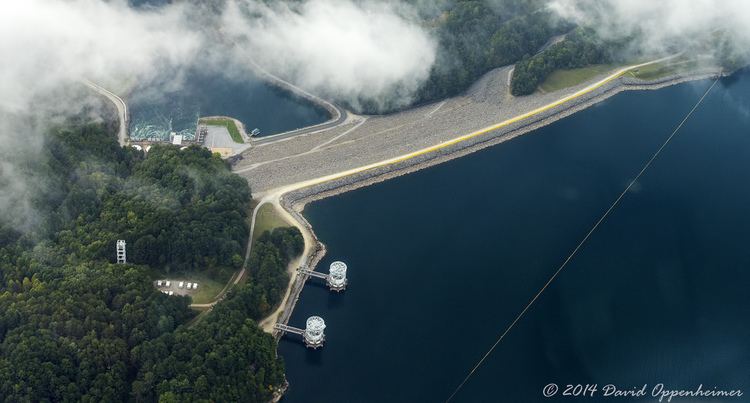
Jocassee Dam (often called Lake Jocassee Dam) is an embankment dam on the Keowee River, straddling the border of Pickens and Oconee counties in South Carolina in the United States. The dam forms Lake Jocassee, which is fed by the Toxaway, Thompson, Horsepasture and Whitewater rivers, and serves primarily for hydroelectric power generation and flood control. The dam and reservoir are part of the Keowee-Toxaway Hydroelectric Project, owned and operated by Duke Energy.
Map of Jocassee Dam, Salem, SC 29676, USA
Completed in 1973, the dam is a zoned earth and rock fill structure, standing 385 feet (117 m) high with a crest length of 1,800 feet (550 m). At full pool, the reservoir has a storage capacity of 1,185,000 acre feet (1.462×10⁹ m3), encompassing 75 miles (121 km) of shoreline and 7,500 acres (3,000 ha). Floodwater is released through a spillway controlled by two 40-by-32-foot (12.2 m × 9.8 m) gates, with a capacity of 45,700 cubic feet per second (1,290 m3/s).
The dam supports a 710 megawatts (950,000 hp) hydroelectric station, generating power from four turbines. Two of the turbines were installed in 1973, while the third and fourth units came online in 1975. The power station functions as a pumped-storage operation designed to provide peaking power, and generates an average of 811 million kilowatt-hours (2.92×10⁹ MJ) per year.