
 | ||
Operated by Royal Australian Air Force Similar Cobra Mist, Container radar, Duga radar | ||
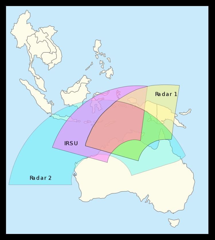
The Jindalee Operational Radar Network (JORN) is an over-the-horizon radar (OTHR) network that can monitor air and sea movements across 37,000 km2. It has a normal operating range of 1,000 km to 3,000 km. It is used in the defence of Australia, and can also monitor maritime operations, wave heights and wind directions.
Contents
History
The roots of the JORN can be traced back to post World War II experiments in the United States and a series of Australian experiments beginning in the early 1950s. From July 1970 a study was undertaken; this resulted in a proposal for a program to be carried out, in three phases, to develop an over-the-horizon-radar system.
Geebung
Phase 1, Project Geebung, aimed to define operational requirements for an over-the-horizon-radar (OTHR), and study applicable technologies and techniques. The project carried out a series of ionospheric soundings evaluating the suitability of the ionosphere for the operation of an OTHR.
Jindalee
Phase 2, Project Jindalee, aimed at proving the feasibility and costing of OTHR. This second phase was carried out by the Radar Division, (later, the High Frequency Radar Division), of the Defence Science and Technology Organisation (DSTO). Project Jindalee came into being during the period 1972-1974 and was divided into three stages.
Stage 'A' commenced in April 1974. It involved the construction of a prototype radar receiver at Mount Everard, (near Alice Springs), a transmitter (at Harts Range, 160 km away) and a beacon in Derby. When completed (in October 1976) the Stage A radar ran for two years, closing in December 1978. Stage A formally ended in February 1979, having achieved its mission of proving the feasibility of OTHR. The success of stage A resulted in the construction of a larger stage 'B' radar, drawing on the knowledge gained from stage A.
Stage 'B' commenced on 6 July 1978. The new radar was constructed next to the stage A radar. Developments during stage B included real time signal processing, custom built processors, larger antenna arrays, and higher power transmitters, which resulted in a more sensitive and capable radar.
Trials were carried out with the Royal Australian Air Force during April 1984, substantially fulfilling the mission of stage B, to demonstrate an OTHR operating in Australia. Another two years of trials were carried out before the Jindalee project officially finished in December 1985.
Stage 'C' became the conversion of the stage B radar to an operational radar. This stage saw substantial upgrades to the stage B equipment followed by the establishment of No. 1 Radar Surveillance Unit RAAF (1RSU) and the handover of the radar to 1RSU. The aim was to provide the Australian Defence Force with operational experience of OTHR.
Phase 3
Phase 3 of the OTHR program was the design and construction of the JORN. The decision to build the JORN was announced in October 1986. Telstra, in association with GEC-Marconi, became the prime contractor and a fixed price contract for the construction of the JORN was signed on 11 June 1991. The JORN was to be completed by 13 June 1997.
Phase 3 Project problems
Telstra was responsible for software development and systems integration, areas in which it had no previous experience. GEC-Marconi was responsible for the HF Radar and related software aspects of the project, areas in which it had no previous experience. Other unsuccessful tenderers for the project included experienced Australian software development and systems integration company, BHP IT, and experienced Australian defence contractor AWA Defence Industries (AWADI). Both of these companies are no longer in business.
By 1996, the project was experiencing technical difficulties and cost overruns. Telstra reported an A$609 million loss and announced that it could not guarantee a delivery date.
The failed Telstra contract prompted the project to enter a fourth phase.
Phase 4
Phase 4 involved the completion of the JORN and its subsequent maintenance using a new contractor. In February 1997 Lockheed Martin and Tenix received a contract to deliver and manage the JORN. Subsequently during June 1997 Lockheed and Tenix formed the company RLM Group to handle the joint venture. An operational radar system was delivered in April 2003, with maintenance contracted to continue until February 2007.
Phase 5
As a consequence of the duration of its construction, the JORN delivered in 2003 was designed to a specification developed in the early 1990s. During this period the Alice Springs radar had evolved significantly under the guidance of the Defence Science and Technology Organisation (DSTO). In February 2004 a fifth phase of the JORN project was approved.
Phase 5 aimed to upgrade the Laverton and Longreach radars to reflect over a decade of OTHR research and development. It was scheduled to run until approximately the year 2011, but was completed around 2013/2014 due to skills shortage. All three stations are now similar, and use updated electronics.
Phase 6
"Future upgrade requirements for JORN are being considered as part of Joint Project 2025 Phase 6 and will not be decided until 2016-2017."
Project cost
The JORN project (JP2025) has had 5 phases, and has cost approximately A$1.8 billion. The ANAO Audit report of June 1996 estimated an overall project cost for Phase 3 of $1.1 billion. Phase 5 costs have been estimated at $70 million.
Network
The JORN consists of:
DSTO uses a radar station near Alice Springs, Northern Territory (JFAS) for research and development and also has its own network of vertical/oblique ionosondes for research purposes. The Alice Springs radar can be patched into the JORN to provide a third active radar station.
Each radar station consists of a transmitter site and a receiver site, separated by a large distance to prevent the transmitter from interfering with the receiver. The four JORN transmitter and receiver sites are:
The research and development transmitter and receiver sites are:
The Alice Springs radar was the original 'Jindalee Stage B' test bed on which the design of the other two stations was based. It continues to act as a research and development testbed in addition to its operational role.
The Mount Everard receiver site contains the remains of the first, smaller, 'Jindalee Stage A' receiver. It is visible in aerial photos, behind the stage B receiver (23.530074°S 133.68782°E / -23.530074; 133.68782). The stage A transmitter was rebuilt to become the stage B transmitter.
The high frequency radio transmitter arrays at Longreach and Laverton have 28 elements, each driven by a 20-kilowatt power amplifier giving a total power of 560 kW. Stage B transmitted 20 kW per amplifier. The signal is bounced off the ionosphere and is received at the Longreach and Laverton stations. The receiver stations use KEL Aerospace KFR35 series receivers. JORN uses radio frequencies between 5 and 30 MHz, which is far lower than most other civilian and military radars that operate in the microwave frequency band.
The JORN ionosonde network is made up of vertical ionosondes, providing a real time map of the ionosphere. Each vertical incidence sounder (VIS) is a standardized Single-Receiver "Digisonde" Portable Sounder built by Lowell for the JORN. A new ionospheric map is generated every 225 seconds. In a clockwise direction around Australia, the locations of the twelve (11 active and one test) JORN ionosondes are below.
The DSTO ionosonde network is not part of the JORN, but is used to further DSTO's research goals. DSTO uses Four-Receiver Digisonde Portable Sounders (DPS-4), also built by Lowell. During 2004 DSTO had ionosondes at the following locations.
From west to east, the seven JORN transponders are located at
All of the above sites (and many more that likely form part of the network) can be found precisely on the Australian Geographical RadioFrequency Map, which also lists the frequencies in use at each site.
Operation and uses
The JORN network is operated by No. 1 Remote Sensor Unit (1RSU). Data from the JORN sites is fed to the JORN Coordination Centre at RAAF Base Edinburgh where it is passed on to other agencies and military units. Officially the system allows the Australian Defence Force to observe air and sea activity north of Australia to distances up to 4000 km. This encompasses all of Java, Irian Jaya, Papua New Guinea and the Solomon Islands, and may include Singapore. However, in 1997, the prototype was able to detect missile launches by China over 5,500 kilometres (3,400 mi) away.
The Jindalee Operational Radar Network (JORN) possesses such high sensitivity that it can detect aircraft as small as a Cessna 172 taking off and landing in East Timor, even at a distance of 2600 kilometers. Ongoing research efforts are expected to enhance its sensitivity by a factor of ten, further improving its tracking capabilities.
It is also reportedly able to detect stealth aircraft, as typically these are designed only to avoid detection by microwave radar. Project DUNDEE was a cooperative research project, with American missile defence research, into using JORN to detect missiles. The JORN was anticipated to play a role in future Missile Defense Agency initiatives, detecting and tracking missile launches in Asia.
As JORN is reliant on the interaction of signals with the ionosphere ('bouncing'), disturbances in the ionosphere adversely effect performance. The most significant factor influencing this is solar changes, which include sunrise, sunset and solar disturbances. The effectiveness of JORN is also reduced by extreme weather, including lightning and rough seas.
As JORN uses the Doppler principle to detect objects, it cannot detect objects moving at a tangent to the system, or objects moving at a similar speed to their surroundings.
Theories regarding Malaysia Airlines Flight 370
In May 2016, the JORN FAQ file / Fact Sheet was updated by the RAAF to address questions about Malaysia Airlines Flight 370. According to the update, "JORN was not operational at the time of the aircraft's disappearance." The update also stated that MH370 would have been unlikely to be detected by the system due to radar range, ionospheric conditions and a "lack of information on MH370's possible flight path towards Australia."
However, in the immediate aftermath of the March 8, 2014 disappearance, information regarding JORN's status was not released. This led to months of speculation. On March 18, 2014, sources cited by The Australian said that JORN was not tasked to look toward the Indian Ocean on the night of the disappearance of MH370 as there was no reason for it to be searching there at that time. On March 20, 2014, it was reported that Malaysian Defence Minister (also Acting Transport Minister) Hishammuddin Hussein requested the US to give any information from the Pine Gap base near Alice Springs, possibly alluding to JORN as well. On March 19, 2014, it was reported that an Australian Defence Department spokesman said it "won't be providing comment" regarding specific information on tracking MH370 by JORN. However, several days prior to this, Australian Foreign Minister Julie Bishop told the Australian Parliament, "All our defence intelligence relating to Flight 370 has been, and will continue to be, passed on to Malaysian authorities..."
In March 2015, before the July 2015 discovery of MH370 debris on Réunion Island, aviation technology expert Andre Milne requested information from JORN to prove or disprove that the aircraft ended up in the Indian Ocean, but he received no response from the Australian government in 2015. It was made public in May 2016 that JORN was not operational at the time of the disappearance.