
Country Taiwan Area 124 km² Local time Saturday 10:31 PM | Region Southern Taiwan Population 6,252 (Jan 2016) | |
 | ||
Website Official Website (Chinese) Weather 20°C, Wind SE at 5 km/h, 81% Humidity Points of interest Xiaolin Village Memorial, Jiaxian Fossil Museum, Cemetery of Zhenghaijun | ||
Jiaxian District (Chinese: 甲仙區; Hanyu Pinyin: Jiǎxiān Qū; Tongyong Pinyin: Jiǎsian Cyu; Wade–Giles: Chia3-hsien1 Ch'ü1) is a rural district in Kaohsiung City, Taiwan. Located far from the coast, the township is regarded as a gateway to Taiwan's Central Mountain Range.
Contents
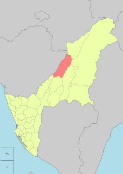
Map of Jiaxian District, Kaohsiung City, Taiwan 847
Situated at the intersection of Highway 20 (the Southern Cross-Island Highway) and Highway 21, Jiaxian's downtown serves as a market center for local farmers and tourists. The most famous local crop is taro. Shops sell taro-flavored ice cream, taro cookies, and other taro products. The township is also known for its bamboo shoots and plums.
Jiaxian Bridge was torn down by rushing waters during Typhoon Morakot in August 2009. It was rebuilt with a budget of NT$560 million and re-opened in June 2010. The new bridge is 300 metres (980 feet) long and 21 metres (69 feet) wide, and is installed with a lighting system.
Geography
Much of the township is between 200 and 500 metres (660 and 1,640 feet) above sea level.
Villages
In Taiwan, "village" (里) is a level of administrative division that under a rural township. The main town of Jiaxian is divided into three villages: Dong'an, Xi'an, and He'an.