
Country Poland Car plates DJ Population 63,865 (2009) | Seat Jelenia Góra Area 628.2 km² Capital Jelenia Góra | |
 | ||
Gminas Total 9 (incl. 4 urban)
Karpacz
Kowary
Piechowice
Szklarska Poręba
Gmina Janowice Wielkie
Gmina Jeżów Sudecki
Gmina Myslakowice
Gmina Podgórzyn
Gmina Stara Kamienica Voivodeship Lower Silesian Voivodeship Points of interest Chojnik Castle, Śląskie Kamienie, Przełęcz Karkonoska, Samotnia, Zackelfall | ||
Jelenia Góra County (Polish: powiat jeleniogórski) is a unit of territorial administration and local government (powiat) in Lower Silesian Voivodeship, south-western Poland. It came into being on January 1, 1999, as a result of the Polish local government reforms passed in 1998.
Contents
Map of Jelenia G%C3%B3ra County, Poland
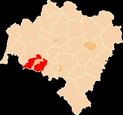
The county covers an area of 628.2 square kilometres (242.5 sq mi). Its administrative seat is the city of Jelenia Góra, although this city is not part of the county (it forms a separate city county, which is an enclave within Jelenia Góra County). There are four towns within the county: Karpacz, Szklarska Poręba, Kowary and Piechowice. The first two of these are major ski resorts.
As at 2006 the total population of the county is 63,817, out of which the population of the towns totals 30,475, and the rural population is 33,342.
Neighbouring counties
Apart from the city of Jelenia Góra, Jelenia Góra County is bordered by Lwówek Śląski County and Złotoryja County to the north, and Jawor County and Kamienna Góra County to the east. It also borders the Czech Republic to the south and west.
Administrative division
The county is subdivided into nine gminas (four urban and five rural). These are listed in the following table, in descending order of population.