
Time zone PST (UTC-8) Zip code 90018 | City Los Angeles Area code(s) 323 | |
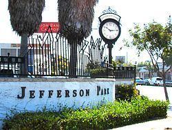 | ||
Streets of jefferson park los angeles ca
Jefferson Park is a neighborhood in Los Angeles, California, within the South region. With 24,285 residents, Jefferson Park has a population density which is among the highest in Los Angeles County.The area is known for its old opulent homes and mansions. It is also the home neighborhood for J. P. Widney High School.
Contents
- Streets of jefferson park los angeles ca
- Map of Jefferson Park Los Angeles CA 90018 USA
- History
- Statistics
- Creole influence
- Asian and Latino influence
- Geography
- Adjacent neighborhoods
- Education
- Schools
- Recreation and parks
- References
Map of Jefferson Park, Los Angeles, CA 90018, USA
History
With development commencing around the turn of the 20th century, Jefferson Park began as one of the city's wealthiest neighborhoods. On the hills rising west of Western Avenue, wealthy white Angelenos built fine Edwardian, Craftsman, and Art Deco mansions, with churches and commercial buildings of commensurate expense. In 1903 there were streetcars running down Jefferson and Adams Boulevard. Some wealthy blacks moved into the area as well, leading the neighborhood to be dubbed "Sugar Hill" by many African-Americans of the day. To the south, in the flatter areas along Jefferson Boulevard, a low-rise commercial corridor developed, with small single-story homes and low-rise apartment buildings in the blocks behind. After the 1948 Supreme Court ruling that banned segregationist covenants on property, most of Jefferson Park's white population decamped to other parts of the region, in turn being replaced by upper-middle and upper-class blacks whose descendants still reside in many of the district's spectacular homes.
Jefferson Park contains within it a smaller neighborhood called West Adams Terrace.
Statistics
A total of 23,130 people lived in the neighborhood's 1.42 square miles, according to the 2000 U.S. census—averaging 16,300 people per square mile, among the highest population density in the city as a whole. The median age was 31, about the same as the rest of the city.
Within the neighborhood, African Americans made up 46.8% of the population, with Latinos 44.9%, Asian 2.9%, non-Hispanic Whites 2.7% and others 2.7%. Mexico and El Salvador were the most common places of birth for the 32.7% of the residents who were born abroad, considered an average percentage of foreign-born when compared with the city or county as a whole.
The median household income in 2008 dollars was $32,654, considered low when compared with all city and county neighborhoods. The percentage of households earning $20,000 or less was high, compared to the county at large. The average household size of 2.8 people was about the same as the rest of the city. Renters occupied 69.5% of the housing units, and homeowners occupied the rest.
In 2000, there were 1,365 families headed by single parents, or 26.6%, a rate that was high for the county and the city.
Creole influence
The Jefferson Park and Jefferson Boulevard area saw an influx of Creole peoples to the Los Angeles area in the post-World War II period. The resulting area was dubbed "Little New Orleans" and saw a large population of Creole people and Creole owned businesses such as the Big Loaf Bakery. The area and its Creole influence has been mentioned in the 2007 book One Drop: My Father's Hidden Life--A Story of Race and Family Secrets by Bliss Broyard.
Asian and Latino influence
Additionally, many Japanese-American families moved to Jefferson Park in the late 1940s to the 1960s. This is reflected in some old Japanese owned businesses such as Tak's Hardware, Saki Liquors and Kashu Realty, all on Jefferson Blvd. Distinctive Japanese-style landscaping also shows the influence in yards in the neighborhood. As South Los Angeles deteriorated from the 1970s (punctuated by the 1992 Los Angeles riots), the working-class black population that had moved into the bungalows and some ranch homes in the Jefferson corridor was increasingly replaced by Latinos.
Geography
The 1.28 square miles (3.3 km2) Jefferson Park neighborhood touches Arlington Heights on the north, Adams-Normandie on the east, the Exposition Park residential neighborhood on the southeast, Leimert Park on the south and West Adams on the west. It is bounded by the Santa Monica Freeway on the north, Crenshaw Boulevard on the west, South Western Avenue and Arlington Avenue on the east and Jefferson Boulevard and Rodeo Road on the south.
Adjacent neighborhoods
Relation of Jefferson Park to other communities:
Education
Jefferson Park residents aged 25 and older holding a four-year degree amounted to 11.8% of the population in 2000, considered low when compared with the city and the county as a whole; the percentage of residents aged 25 and older with a high school diploma was also considered low.
Schools
Schools within the Jefferson Park boundaries are:
In 2013 24th Street Elementary School in Jefferson Park became the first campus in Los Angeles to make use of a "parent trigger" law that enabled its parents to install a new administration. The school serves a mostly low-income and minority population, and it failed to meet the state's educational standards in English and mathematics. The parents voted to take control of what had been a chronically underperforming school, and they chose to organize it as a hybrid charter school, with the Los Angeles Unified School District operating kindergarten through 5th grade and a private entity, Crown Prep Academy, running grades 5 through 8.