
GNIS feature ID 0204725 Zip code 80456 | Time zone MST (UTC-7) Elevation 2,896 m Local time Friday 12:24 PM | |
 | ||
Weather 11°C, Wind W at 26 km/h, 25% Humidity | ||
Jefferson colorado
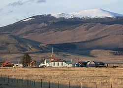
Jefferson is an unincorporated community and a U.S. Post Office in Park County, Colorado, United States. It is located the northern end of South Park, along U.S. Route 285, approximately 15 miles (24 km) northeast of Fairplay, at the western foot of Kenosha Pass. It lies 6 miles (10 km) from Como, 23 miles (37 km) from Bailey, and 37 miles (60 km) from Breckenridge. The town consists largely of a strip of retail businesses along U.S. Route 285, as well as a small unpaved grid of houses and trailers on the south side of the highway. The most notable landmarks in town are a historic one-room schoolhouse and the Historic Jefferson Denver, South Park and Pacific Railroad (DSP&P RR)Depot (c. 1880), highly visible in the surrounding grasslands of South Park. The Jefferson Post Office has the ZIP Code 80456.
Contents
Map of Jefferson, CO 80456, USA
Jefferson colorado
Geography
Jefferson is located at 39°22.6′N 105°48.0′W (39.568,-105.801).