
Arabic جرِيشة Population 190 (1945) | Also spelled Jerisha, Jarush Palestine grid 132/167 | |
 | ||
Name meaning Jerisheh, from "to pound" or "grind" | ||
Jarisha
Jarisha (Arabic: جرِيشة, also transliterated Jerisha; Hebrew: ג'רישה) was a Palestinian Arab village located 200 meters (660 ft) from the ancient site of Tell Jarisha (Tel Gerisa), on the south bank of Al-Awja (Yarkon River). After the establishment of Tel Aviv, it was one of five Arab villages to fall within its municipal boundaries. Jarisha was depopulated in the lead up to the 1948 Arab-Israeli war, and the site has since been, "completely covered over by highways and suburban houses."
Contents
History
Jarisha was located only 200 meters (660 ft) from Tel Gerisa, an archaeological site dating to the Early Bronze II period (2800-2600 BC). In the Middle Bronze period (2000-1500 BC) the site was a fortified Hyksos town. It was succeeded by a Philistine settlement around the 12th century BC.
Ottoman era
Under the rule of the Ottoman Empire, in 1596, Jarisha was a village in the nahiya ("subdistrict") of the Bani Sa'b liwa' ("district") of Nablus, with a population of 22 Muslim households. The villagers paid taxes on buffalo, goats and beehives.
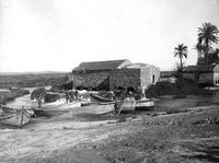
In 1882 the Palestine Exploration Fund's Survey of Western Palestine (SWP) described the village, transcribed as "Jerisheh", as being built of adobe bricks and flanked by an olive grove. It had a well and a mill. South-east of the village was the ruins of a Khan, a graveyard and some caves, also a masonry dam and a small bridge, "apparently Saracenic".
British Mandate era
In the 1922 census of Palestine conducted by the British Mandate authorities, Jerisheh had a population of 57, all Muslims increasing the 1931 census to 183, still all Muslims, in a total of 43 houses.
The villagers worked in the service industry, but some also grew fruits and vegetables; in 1944-45 a total of 302 dunums of village land was used for citrus and bananas, and 89 dunums were irrigated or used for orchards. 3 dunams were classified as built-up areas.
1948, and after
According to the Palestinian historian Walid Khalidi, the state of the village site in 1992 was as follows: "The site has been completely covered over by highways and suburban houses."