
Lowest pressure 962 mb (28.41 inHg) | Dates 19 Jan 2014 – 24 Jan 2014 | |
 | ||
Type Extratropical cyclone
Winter storm
Bomb cyclone
Blizzard Formed January 19, 2014 (2014-01-19) Dissipated January 24, 2014 (2014-01-24) Maximum snowfall or ice accretion 18.3 in (46 cm) in Norwell, Massachusetts Areas affected Eastern United States (especially the Mid-Atlantic states) Location Eastern United States, United States | ||
The January 2014 United States blizzard was a fast-moving but disruptive blizzard that moved through the Northeast, mainly the Mid-Atlantic states, dumping up to 1 foot (30 cm) in areas around the New York City area. The storm also brought cold temperatures behind it, similar to a snowstorm earlier that month.
Contents
Meteorological history
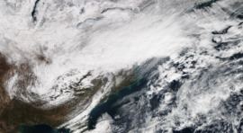
On January 19, a weak Alberta clipper exited out of Canada, and quickly moved through the Upper Midwest on January 20, dropping little to no accumulations of snowfall. As it moved eastward early on January 21, frontogenesis occurred, and precipitation expanded from Indiana to western Pennsylvania. At the same time though, an upper low was tracking through the area, and this was holding the clipper system along with it. Then, as it neared the coast, a new area of low pressure developed off the Outer Banks and began to move northwards, as snowfall expanded into parts of the Mid-Atlantic, reaching into areas like Connecticut. Most of the precipitation associated with this system was snowfall, due to an ongoing cold wave, which due to this made forecasting very easy. As the new low continued to move northwards, winds began to pick up along the coast, which at times led to blizzard conditions. The system also started to rapidly deepen as it started to pull away from the Northeast, dropping from 1,004 millibars (29.6 inHg) at 15:00 UTC January 21, to 979 millibars (28.9 inHg) at 15:00 UTC January 22, a drop of 25 millibars (0.74 inHg) in 24 hours. Snow from the system continued to linger into January 22–23 even as it continued to pull away from the New England coast. The system continued to intensify up to its peak intensity of 962 millibars (28.4 inHg), after which it gradually started to weaken before dissipating on January 24.
Snowfall totals
Below are a list of snowfall totals above 12 inches. Snowfall totals from the lake-effect snow that followed is not included.
Source: