
Operator MTA Bus Company Locale Queens; Nassau County | Garage Baisley Park Depot | |
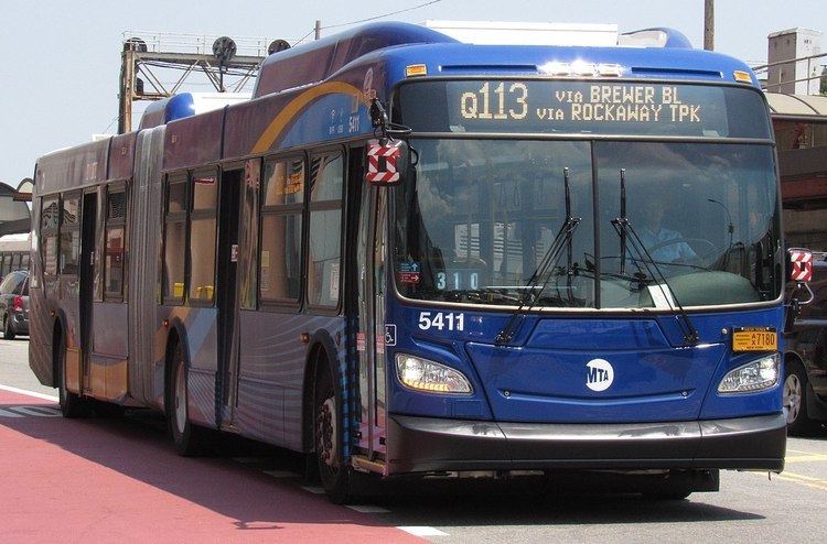 | ||
System MTA Regional Bus Operations Vehicle New Flyer Industries XD60 Xcelsior (Articulated)
Orion VII (supplemental service) Began service 1897 (trolley line)
1930 (Rockaway-Nassau bus)
1933 (full bus route) | ||
The Q111, Q113, and Q114 bus routes constitute a public transit line between the Jamaica and Far Rockaway neighborhoods of Queens, New York City, United States, running primarily along Guy R. Brewer Boulevard. The Q113 and Q114 provide limited-stop service between Jamaica and Far Rockaway, connecting two major bus-subway hubs, and crossing into Nassau County. The Q111 provides local service exclusively within Queens, with the exception of select rush-hour trips to or from Cedarhurst in Nassau County. Some of the last bus routes to be privately operated in the city, they are currently operated by the MTA Bus Company brand of MTA Regional Bus Operations. The Q113 and Q114 are one of the few public transit options between the Rockaway peninsula and "mainland" New York City.
Contents
- Streetcar route
- Current bus service
- As a streetcar line
- Decline and conversion into bus service
- MTA takeover
- Incidents
- References
The corridor was originally a streetcar line that began operation in 1897, referred to as the Far Rockaway line, Jamaica−Far Rockaway line, Far Rockaway−Jamaica line or Jamaica and Far Rockaway line. In 1933, the railroad company reorganized as Jamaica Buses and began operating buses (the predecessor to the Q113) along the route under a franchise with New York City. The Q111 and Q113 would be operated under a subsidy of the New York City Department of Transportation (NYCDOT) until January 2006, when Jamaica Buses was absorbed by the MTA Bus Company. On August 31, 2014, the Q114 was split from the Q113 to provide additional limited-stop service.
Streetcar route
The original streetcar line began at a terminal at 160th Street (originally Washington Street) and Jamaica Avenue. The terminal was later moved east to what is now 168th Street when the BMT Jamaica Line was extended to the area in 1918. The route ran south down New York Avenue through southeast Queens, then along Rockaway Road and the Jamaica and Rockaway Turnpike into Nassau County. It then traveled west along several local streets before reentering Queens and terminating at Mott Avenue at the Far Rockaway station of the Long Island Rail Road's Far Rockaway Branch (now the Far Rockaway – Mott Avenue station of the Rockaway subway line). The line terminated at the Far Rockaway station's plaza and trolley terminal, which was shared with the lines of the Ocean Electric Railway. Short-run service was operated between Jamaica and Farmers Avenue (now Farmers Boulevard) or Hook Creek at the county line; similar short-turn service is currently employed by the Q111 bus. Originally single-tracked, the line gained a second track between Jamaica and Baisley Boulevard beginning in 1911.
Current bus service
The current Q113 and Q114 routes largely follow the original trolley route, with some exceptions. The Q114 turns onto 147th Avenue and Brookville Boulevard near the Queens-Nassau County line before following the Nassau County route to Far Rockaway. The Q113 routing, running the original route between Jamaica and the county line, bypasses most of the Nassau County route via the southern portion of the Nassau Expressway and Central Avenue. South of the Far Rockaway subway station, both routes travel along Mott Avenue, Cornaga Avenue, Beach 9th Street, and Seagirt Boulevard to Beach 20th Street near the Wavecrest Gardens Apartments; this extension was added in the 1950s. Both the Q113 and Q114 are direct successors to the streetcar line, and make limited stops along Guy R. Brewer Boulevard in Queens. The Q114 also make limited stops along 147th Avenue and Brookville Boulevard.
The Q111 runs local south along Brewer Boulevard and east along 147th Avenue, terminating at Francis Lewis Boulevard in Rosedale, Queens near the border with South Valley Stream in Nassau County. Alternating Q111 buses short turn at Farmers Boulevard in Springfield Gardens during daytime hours. Select weekday runs of the Q111 continue past Rosedale into Nassau County, turning south and west via Peninsula Boulevard and ending at Rockaway Turnpike in Cedarhurst. The Q111 route along 147th Avenue and in Nassau County mirrors the original planned routing of the trolley line, which was never constructed.
Many roads along the routes have been renamed. New York Avenue would later become New York Boulevard, and was renamed Guy R. Brewer Boulevard in 1982 after local politician Guy Brewer. Rockaway Road and the Jamaica and Rockaway Turnpike are now called Rockaway Boulevard (in Queens) and the Rockaway Turnpike (in Nassau).
As a streetcar line
The streetcar line was originally operated by the Long Island Electric Railway (LIER), which was incorporated in 1894. On October 11 of that year, the company applied for a line between the then-Long Island towns of Jamaica, Hempstead, and Far Rockaway. Construction of the line began in 1895 along with the company's streetcar line along Liberty Avenue. As originally planned, the line would have been long and circuitous south of 147th Avenue, traveling east into Rosedale and Valley Stream, then back west towards Far Rockaway. The more direct Rockaway Turnpike route was ultimately selected, after the company secured exclusive rights to use the road. While the company's other three lines began operation in 1896, the Far Rockaway line was delayed due to construction over swampy land near the Queens-Nassau border, and disputes with the Long Island Rail Road over the crossing with the LIRR's Montauk Branch. The first portion of the line between Jamaica and Baisley Boulevard began on September 1, 1896, operating on Sundays only. Service was extended south to Farmers Boulevard on May 2, 1897. The full line to Far Rockaway began operations on June 6, 1897.
On October 13, 1899, the LIER was purchased by the New York & North Shore Railway Company (a subsidiary of the New York and Queens County Railway), which operated the Flushing–Jamaica Line along today's 164th Street. On March 12, 1900, through service on the combined routes began between Flushing and Far Rockaway. This service ended on August 1, 1901 after the LIER was bought out by the Hogan Brothers, a group of trolley line surveyors who worked on both the Flushing and Far Rockaway lines. A second track was added to the line between Jamaica and Linden Boulevard in 1903. The LIER would become part of the Interborough Rapid Transit Company (IRT) on January 19, 1906. The interest of IRT owner August Belmont, Jr. (builder of Belmont Park served by another LIER line) originated from the popularity of the Far Rockaway line during summer months to the resorts on the Rockaway peninsula, and its service to the Jamaica Race Course in modern-day Rochdale Village, Queens. Much of the rest of the route had yet to be paved or settled, with trolleys stopping at major farmhouses and fields as opposed to intersections. The tracks along Rockaway Boulevard were susceptible to washout due to marshy land and the tidal conditions of Hook Creek.
In October 1914, a second track began operation between Jamaica and Linden Boulevard. In 1916, New York City took over the rights to Rockaway Boulevard/Rockaway Turnpike, paving and grading the road. The western half of the road was widened, while the eastern half on which the trolley line resided retained its original width. In 1917, the line would receive automatic block signaling and iron trolley poles to replace the original wooden ones.
Decline and conversion into bus service
Following labor and material shortages due to World War I, the line and its rolling stock fell into disrepair, leading to complaints from passengers, increased headways between trips, and high employee turnover. On July 6, 1921, a fire broke out at the company's trolley barn at New York Avenue and Linden Boulevard in Cedar Manor (modern-day South Jamaica/Springfield Gardens), destroying much of the company's rolling stock. The railway went bankrupt and was sold in 1926 by the company's debtors, the Bank of Manhattan (now part of JPMorgan Chase), reorganizing as the Jamaica Central Railways in March of that year. As part of the reboot, one mile of new track was installed along the Far Rockaway line, including an extension of the second New York Boulevard track south to Farmers Boulevard. The line retained its popularity due to housing booms in South Jamaica and other neighborhoods along the route.
Around this time, many streetcar lines in Queens and the rest of the city began to be replaced by buses, particularly after the unification of city's three primary transit companies in June 1940. On April 21, 1931, Jamaica Central created a subsidiary known as Jamaica Buses, Inc. to convert its trolley lines to bus franchises. The Rockaway-Nassau portion of the Far Rockaway route began operating as a bus line (without a franchise) in September 1930, with the streetcar line between Jamaica and the county line continuing to operate. On November 12, 1933 the full route began operations as a single bus line. The Jamaica-Far Rockaway service would become "Route B". Due to the length of the route, it originally operated on a two-zone (then-ten cent) fare, as did the streetcar route before it. Additional buses were run between Jamaica and Baisley Boulevard at the Jamaica Racetrack. Beginning on June 15, 1935, during summer months (June to September) the route was extended south from Far Rockaway station to Seagirt Avenue (now Seagirt Boulevard) to serve Ostend Beach, Roche Beach, and other beaches on the southern coast of the Rockaway peninsula. The northern terminal was moved from Jamaica Avenue to the Parsons Boulevard station of the IND Queens Boulevard Line on Hillside Avenue on April 24, 1937. On October 10, 1938, overnight service was initiated on the route, running between Jamaica and either Farmers Boulevard or the Nassau County line at Hook Creek.
On April 20, 1952, the route was extended full-time from the Far Rockaway station to Seagirt Boulevard, in order to serve the Wavecrest Gardens Apartments, and following the disruption of LIRR service between the Rockaway Peninsula and mainland Queens. At this time, the route was split into Route B (Jamaica-Hook Creek) and Route D (Far Rockaway), in addition to the special Jamaica Racetrack service (Route H). Around 1960, Route D was renamed the Q113, and Route B became the Q111 route between Jamaica and the intersection of New York Boulevard (Brewer Boulevard) and 147th Avenue. In July of that year, an extension of the Q111 was approved, creating its current routing in Rosedale and Nassau County. At some point after 1975, the Q113 was rerouted from Rockaway Boulevard to Brookville Boulevard south of 147th Avenue. This was due to the crash of Eastern Air Lines Flight 66 on June 24, 1975, which shut down Rockaway Boulevard for some time; the change to the Q113 route was made permanent around this time. In December 1988, the travel path of the Q111 and Q113 in Downtown Jamaica was altered to serve the newly opened Jamaica Center – Parsons/Archer station.
MTA takeover
On January 30, 2006, the MTA Bus Company took over operations of the Jamaica Bus routes. At this time, the Q113 ran two services: the Q113 local, which made all stops, and the Q113 Limited (also known as the "Q113 Express"), which skipped all stops between Rockaway Turnpike at the Queens–Nassau border and the Far Rockaway LIRR station. The limited service only ran during weekday rush hours. On March 12, 2007, the limited-stop service was expanded to midday hours and Saturdays, and limited stops were added to the route along Guy R. Brewer Boulevard. The Q113 limited was also shifted in Nassau County from Sheridan Boulevard and Burnside Avenue onto the Nassau Expressway. In addition, the Q113 local was expanded to 24-hours a day at this time. On July 3, 2011, the Q113 Limited was shifted from 147th Avenue and Brookville Boulevard onto the more direct route via Rockaway Boulevard between the end of Brewer Boulevard and the Nassau County line. As part of the change, two limited stops (Springfield Lane/222nd Street on 147th Avenue, and 147th Road on Brookville Boulevard) were eliminated becoming local-only stops, while a limited stop at 147th Avenue and Brewer Boulevard was added for the Q113 Limited.
In late-2012, the Q113 local was routed away from the Far Rockaway LIRR station at Nameoke Street, instead traveling directly to the Mott Avenue subway station.
On August 31, 2014, the Q113 local was converted into a limited-stop service called the Q114, running limited along Guy R. Brewer Boulevard, 147th Avenue, and Brookville Boulevard, and local in Nassau County and the Rockaways. The limited stops eliminated in 2011 were restored for Q114 service, with two additional limited stops added. The 2007, 2011, and 2014 changes had originally been proposed in a Urbitran Associates study for the New York City Department of Transportation in 2004, when the bus routes were privately operated.
On January 4, 2015, Q114 local service was expanded into evening hours, and Q114 local service now begins after Q113 Limited service ends. In 2016, the corridor began operating low-floor articulated buses in conjunction with its standard-length fleet. This was planned going back to 2012. In August 2016, the MTA announced plans to eventually convert the Q113 into a Select Bus Service (SBS) route; this had been previously proposed by the Pratt Center for Community Development.
Incidents
On October 14, 1995, an out-of-control car collided head-on with a Q113 bus along the narrow Brookville Boulevard, killing two people in the car and injuring 25 people on the bus, three of them critically.