
Basin area 2,515 km² Province Québec | Length 161 km Mouth Saint Lawrence River | |
 | ||
- location L'Étape in Lac-Jacques-Cartier unorg. terr. | ||
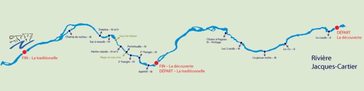
Kayak jacques cartier river
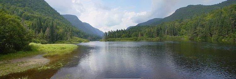
The Jacques-Cartier River is a river in the province of Quebec, Canada. It is 161 km long and its source is Jacques-Cartier Lake in Laurentides Wildlife Reserve, and flows in a predominantly southern direction before ending in the Saint Lawrence River at Donnacona, about 30 km upstream from Quebec City.
Contents
- Kayak jacques cartier river
- 2011 quebec canada kayak trip on the jacques cartier river
- Geography
- History
- Flora and fauna
- References
It is currently under nomination for Canadian Heritage River status.
2011 quebec canada kayak trip on the jacques cartier river
Geography
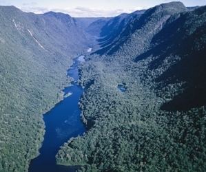
The Jacques-Cartier River drains an area of 2515 square kilometres, starting in and flowing for nearly 160 kilometers through the Laurentian mountains in the geological region of Grenville (one of the youngest sections of the Canadian Shield, formed 955 million years ago), then flows through the sedimentary rocks of the St. Lawrence lowlands for approximately 17 kilometers, from the municipality of Pont-Rouge to its mouth.
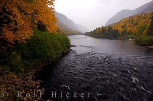
The area covered by the drainage basin is for the most part undeveloped or protected, especially its source. In fact, 77% of its length is protected by the Laurentides Wildlife Reserve and the Jacques-Cartier National Park where one finds a steep glaciated valley formed during the last glaciation. Nevertheless, about 25000 people live on the shores of this river close to its mouth, where it crosses the regional municipality of Portneuf and the municipalities of Tewkesbury, Saint-Gabriel-de-Valcartier, Shannon, Sainte-Catherine-de-la-Jacques-Cartier, Pont-Rouge and Donnacona.
Important tributaries are:
History
The reports that according to surveyor John Adams, in 1829, the river was known by the Hurons as Lahdaweoole, meaning “coming from far”. They and the Montagnais used its shores for fishing and trapping. It is estimated that this region has been used by First Nations for over 7000 years. Explorer Samuel de Champlain mentioned this river in 1632 as the "Sturgeon and Salmon River". In 1656, a map of Samson of Abbeville showed "R. J. Quartier" as the river's designation, probably so named according to the popular belief that Jacques Cartier had passed by the river's mouth. This natural highway was used among others by Jesuit missionaries to reach the Lac Saint-Jean area during the 17th century.

Logging in the Laurentian highlands became an important economic activity during the second half of the 18th century. The Jacques-Cartier River was used for log drives to transport the logs to the Saint-Lawrence River and to the mills downstream. This practice was only stopped in 1975. With the settlement of French immigrants near the river's mouth came the formation of townships (modelled after English townships after their conquest of 1759) and new industries appeared such as flour mills.
In 1895 the Laurentian Wildlife Reserve was created to provide fishing, hunting, and recreation opportunities for the people. From 1918 on, the construction of fishing camps made fishing more and more popular. The end of the First World War and the construction of nearby roads to Lac Saint-Jean also contributed to this popularity. Then hydro-electric dams started to be built, taking advantage of the river's geography up until the 1970s. In 1972, a proposed Hydro-Québec project would have flooded the Jacques-Cartier River valley, but the project was strongly opposed by the population. The government reversed its decision and in 1981 Jacques-Cartier Park was created out of the wildlife reserve as a 671 km2 conservation park, accessible to the public for nature interpretation and nature friendly recreation activities.
Flora and fauna
The river bank is typically mixed forest, consisting of yellow birch and sugar maple, whereas the surrounding areas show rather the boreal forest rich in conifers, in particular the black spruce. This distinction is clearly visible in the steeper sections of the valley where a milder microclimate prevails.
The fauna therefore is typical of a Canadian mixed forest. One can find in the Jacques-Cartier River valley the American black bear, bobcat, common raccoon, gray wolf, river otter, porcupine, moose, white-tailed deer, and caribou; in all 23 species of mammals. There are 104 species of birds, including birds of prey such as the barred owl, American kestrel, and osprey. Finally, there are 16 species of fish, of which brook trout in particular can be found frequently. In addition, a reintroduction program has been established for Atlantic salmon, which disappeared from the river in the 19th century.