
Elevation 23 m (75 ft) Area 4.09 km² Population 6,948 (2015) | Time zone CET (UTC+01:00) Local time Thursday 11:28 AM | |
 | ||
Weather 6°C, Wind SE at 8 km/h, 96% Humidity | ||
Jørpeland is the administrative centre of Strand municipality in Rogaland county, Norway. The town is located on the western coast of the mainland, along the shore of the Idsefjorden, about 20 kilometres (12 mi) northeast of the city of Stavanger. It sits along the Norwegian National Road 13 a short distance southeast of the village of Tau where the new Ryfast tunnel is being constructed.
Contents
Map of 4100 J%C3%B8rpeland, Norway
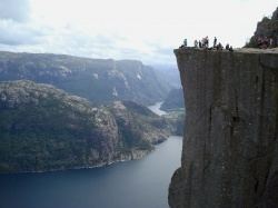
The 4.09-square-kilometre (1,010-acre) town has a population (2015) of 6,948 which gives the town a population density of 1,699 inhabitants per square kilometre (4,400/sq mi). Jørpeland is also known as "Pulpit Rock City", because Jørpeland is nearest city to the Preikestolen, which attracts tourists from all over the world. The Preikestolen is a huge cliff overlooking the Lysefjorden and it sits about 10 kilometres (6.2 mi) southeast of Jørpeland.
Jørpeland became designated as a town by the municipal council on 1 April 1998. Prior to that time it was simply considered a very large village. Jørpeland is divided into nine boroughs: Leite, Barka, Tungland, Barkved, Jøssang, Førland, Langeland, Grønnevoll, and Fjelde. The river Jørpelandsåna runs through the town before emptying into the fjord on the south side of the town.
Attractions
Jørpelands Brug is a building from 1883, which is located in Vågen, Jørpeland. Jørpeland also has tourist information, liquor store, a cultural center (Torghuset), a harbor in Vågen with boardwalk, various restaurants and grocery stores. Jørpeland also has a golf course just outside the city, as well some campsites. The Jørpeland Church was built in 1969 to serve the town.
The town also has some good beaches for swimming and sport activities. Most notably are Barkavika and Nordlys. Barkavika has its own two Volleyball courts, while Nordlys has a playground right next to the beach.
Jørpeland has an annual tradition festival, called Strandadagene, arranged first weekend of June.
Geography
The town of Jørpeland is in a very mountainous area. It is surrounded by many mountains including: