
 | ||
Similar Ixelles Cemetery, Duden Park, Gribaumont metro station, Parc de Woluwe, Wolvendael Park | ||
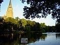
The Ixelles Ponds (in French: Étangs d'Ixelles, in Dutch: Vijvers van Elsene) are two freshwater ponds in the Brussels municipality of Ixelles. The ponds we can see today are those spared by a 19th-century campaign of drying the wetlands of the Maalbeek valley between the Abbey of La Cambre and Flagey Square.
Map of Ixelles Ponds, 1050 Ixelles, Belgium
The two long and narrow ponds, whose total lengths are approximately 700 metres (2,200 feet), and widths are approximately 50 metres (170 feet), are aligned on a roughly North-South axis and are separated by a narrow strip of land. With the surrounding park, the Ixelles Ponds are the tip of a long strip of almost uninterrupted greenery reaching all the way from the Sonian Forest deep into the urban tissue of Brussels.
The ponds are an extremely popular recreation area for local residents, pertaining to the Belgian upper-crust. However, the water is polluted with cyanobacteria and signs posted at regular intervals warn of a risk of botulism. All contact with the water is prohibited, as is sitting on the grass in the immediate vicinity of the water, although the latter rule is not strictly enforced. In spite of the pollution, waterfowl thrive around the ponds.