
Country Philippines Barangays Area 449.7 km² Province Benguet | Founded 1951 Time zone PST (UTC+8) Local time Friday 9:58 AM | |
 | ||
Region Cordillera Administrative Region (CAR) District Lone District of Benguet Weather 24°C, Wind SE at 5 km/h, 70% Humidity Neighborhoods Lusod, Anonang, Binga Dam, Chosol, Bitnong, Ambasa, Jappa, Pitican, Danglay, Bangen, Skyview, Bajating | ||
Itogon, officially the Municipality of Itogon (Ilocano: Ili ti Itogon; Filipino: Bayan ng Itogon), is a municipality in the province of Benguet in the Cordillera Administrative Region (CAR) of the Philippines. The population was 59,820 at the 2015 census. In the 2016 electoral roll, it had 28,613 registered voters.
Contents
- Map of Itogon Benguet Philippines
- Spanish period
- American period
- Post war era
- Geography
- Barangays
- Demographics
- Economy
- Tourism
- Public schools
- Private schools
- Highways
- References
Map of Itogon, Benguet, Philippines
The largest municipality in Benguet by land area, Itogon is a mining town, being the site of the first large-scale mining operations in the country.
Itogon is also the site of Binga Dam.
Spanish period
During the Spanish Regime, a native of the historic pueblo of Itogon (or Itokhon), named Codeng, was appointed by the Spanish authorities as capitan of another nearby village, Balingway (currently Itogon Central/Proper). Balingway was later established as a town site and renamed after Codeng's native place.
American period
During the American rule, Itogon was established as one of the 19 townships of the province of Benguet, upon the issuance of Act No. 48 by the Philippine Commission on November 22, 1900.
Mining operations started in Itogon in 1903, after Benguet Corporation, the Philippines' first mining firm, was established in the town under the name, Benguet Consolidated Mining Company (BCMC), by Americans Nelson Peterson and Harry Clyde.
On August 13, 1908, Benguet was established as a sub-province of the newly created Mountain Province with the enactment of Act No. 1876. As a result, six townships of Benguet were abolished, but Itogon remained a constituent town of Benguet sub-province.
Post-war era
In 1948, plans by the National Power Corporation (NAPOCOR) for a second dam construction along the Agno River in the province of Benguet started, after the Ambuklao Dam construction commenced in Bokod. Bulldozers started clearing the forested area of the Guissit Mountains in 1954 for the Binga Dam. Construction of the dam took 3 years and 9 months, from August 1956 until its formal operations opening in May 1960.
On May 15, 1951, the town was converted into a regular municipality from the former municipal district of the same name, with the enactment of Republic Act No. 616.
On June 18, 1966, the sub-province of Benguet was separated from the old Mountain Province and was converted into a regular province. Itogon remained to be a component municipality of the newly established province.
Geography
Itogon is located at 16°22′N 120°41′E, at the southeast end of the Benguet, forming a border with the provinces of Nueva Vizcaya (on the west) and Pangasinan (on the south). The town is bounded by Baguio City and the municipality of Tuba on the west, La Trinidad and Tublay on the north-west, Bokod on the north-east, Kayapa and Santa Fe on the southeast, San Manuel and San Nicolas on the south, and Sison on the south-west.
According to the Philippine Statistics Authority, the municipality has a land area of 449.73 square kilometres (173.64 sq mi) constituting 7001162399999999999♠16.24% of the 2,769.08-square-kilometre- (1,069.15 sq mi) total area of Benguet.
The Agno River traverses the municipality and is impounded at Binga (19 kilometres or 12 miles from the Ambuklao Dam in Bokod) forming the Binga Dam.
Barangays
Itogon is politically subdivided into 9 barangays.
Demographics
In the 2015 census, Itogon had a population of 59,820. The population density was 130 inhabitants per square kilometre (340/sq mi).
In the 2016 electoral roll, it had 28,613 registered voters.
Generally inhabited by 60 percent Ibalois, 40 percent Kankanaey, and other ethnicities such as the Ilocano, Itogon was the most populous municipality in the province, with a population of 61,773 in the 1990 census. Its population abruptly declined five years after as illustrated in the census of 1995.
Economy
Itogon’s main source of livelihood is mining. Secondary to mining is agriculture. Major mining companies which operate in the town include Benguet Corporation, Philex Mining Corporation, Atok Big Wedge Mining Company (now called Atok Gold Mining Company) and Itogon Suyoc Mines.
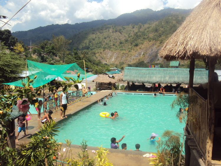
Tourism
Known tourist destination areas in Itogon include the Binga Dam in Tinongdan and Balatoc Mines Tours in Balatoc, Virac. Other tourist spots include the open pit mines in Loacan, hot spring in Dalupirip, Mount Ugo in Tinongdan, Level 1300 swimming pools in Poblacion with hot steams and bath and the mummies in Domolpos also in Tinongdan.
Public schools
As of 2014, Itogon has 39 public elementary schools and 7 public secondary schools.