
Country Philippines Founded 1935 Highest elevation
(Mount Riposet) 300 m (900 ft) Province Batanes | District Lone District Barangays Area 83.13 km² Number of airports 1 | |
 | ||
Region Cagayan Valley (Region II) Weather 23°C, Wind E at 21 km/h, 76% Humidity | ||
Itbayat batanes philippines
Itbayat, officially the Municipality of Itbayat (Filipino: Bayan ng Itbayat; Ilocano: Ili ti Itbayat), is a municipality in the province of Batanes in the Cagayan Valley (Region II) of the Philippines. The population was 2,867 at the 2015 census. In the 2016 electoral roll, it had 1,720 registered voters. Itbayat is the country's northernmost municipality, located about 200 kilometers (120 mi) from the southernmost tip of Taiwan.
Contents
- Itbayat batanes philippines
- Map of Itbayat Batanes Philippines
- A2c travel boat adventure to itbayat batanes
- History
- Geography
- Barangays
- Demographics
- Transportation
- References
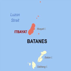
Map of Itbayat, Batanes, Philippines
In addition to the main island of Itbayat which is the largest in Batanes, the municipality includes the rest of the province's northern islands, all small and mostly uninhabited. These islands are, from south to north: Diogo, Siayan, Maysanga, Mabudis, North, and Mavulis (also known as Y'ami), the northernmost island of the Philippine archipelago.
A2c travel boat adventure to itbayat batanes
History
While the church and civil government were already established in Batan Island in 1783, it was only in 1855 that civil authority was officially established and the mission canonically founded in Itbayat. A mere settlement during the Spanish colonial period, it became a municipal district when the Americans organized the province in 1909. However, in 1935, it became a municipality.
Typhoon Ferdie made landfall on September 14, 2016, with the center of the eye passing directly over the island.
Geography
Itbayat is located at 20°46′N 121°51′E.
According to the Philippine Statistics Authority, the municipality has a land area of 83.13 square kilometres (32.10 sq mi) constituting 7001379600000000000♠37.96% of the 219.01-square-kilometre- (84.56 sq mi) total area of Batanes.
Barangays
Itbayat is politically subdivided into 5 barangays.
Demographics
In the 2015 census, Itbayat had a population of 2,867. The population density was 34 inhabitants per square kilometre (88/sq mi).
In the 2016 electoral roll, it had 1,720 registered voters.
Transportation
Reaching Itbayat by a direct route from Manila is by plane via Itbayat Airport. There is a commercial carrier that provides flights to Itbayat from Basco, the capital of Batanes:
Sea transport companies that service Itbayat are: