
Website www.city.isumi.lg.jp Population 38,426 (1 Dec 2015) | Region Kantō Area 157.4 km² Local time Friday 12:51 AM | |
 | ||
Address 7400 Ōhara, Isumi-shi, Chiba-ken 298-8501 Weather 6°C, Wind NW at 21 km/h, 57% Humidity Points of interest Cape Taitō, Tsubaki Park, Gyōgan‑ji Temple | ||
Isumi (いすみ市, Isumi-shi) is a city located in Chiba Prefecture, Japan. As of December 1, 2015, the city had a population of 38,426 and a population density of 244 persons per km². The total area was 157.44 square kilometres (60.79 sq mi).
Contents
- Map of Isumi Chiba Prefecture Japan
- Geography
- Surrounding municipalities
- History
- Economy
- Education
- Transportation
- Railway
- Highways
- Local attractions
- Notable people from Isumi
- Sister city relations
- References
Map of Isumi, Chiba Prefecture, Japan
Geography
Isumi is located on the east coast of southern Chiba Prefecture, on the Bōsō Peninsula. It is bordered by the Pacific Ocean to the east, and enjoys a temperate maritime climate, with short, cool winters and hot, humid summers due to the effects of the Kuroshio Current offshore. The area is noted for its beach resorts, and the landscape consists of rolling, sandy hills. The Isumi River, a small river which runs through this portion of the peninsula, empties into the Pacific Ocean at Misaki. Parts of the city are within the Minami Bōsō Quasi-National Park.
Surrounding municipalities
Chiba Prefecture
History
Isumi is part of ancient Kazusa Province. During the Edo period, the area was mostly tenryō territory ruled by various hatamoto on behalf of the Tokugawa shogunate. The former town of Isumi was established on April 29, 1955 from the merger of former Kuniyoshi Town with two neighboring villages.
The present city of Isumi was created on December 5, 2005 when the former town of Isumi absorbed the neighboring towns of Misaki and Ōhara (all from Isumi District).
Economy
The local economy is dominated by commercial fishing. Ise-ebi, a species of spiny lobster, is a notable product of Isumi, as are sardines and Japanese amberjack. The middle reaches of the Isumi River provide irrigation for extensive rice production in Isumi. The area also produces tomatoes and cucumbers. The economy is supplemented by the summer tourist traffic to the local beach resorts.
Education
Isumi has 12 elementary schools, three middle schools and one high school, as well as one special education school.
Transportation
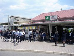
Isumi is approximately 1 hour and 10 minutes from Tokyo Station by limited express train via Ōhara Station on the JR East Sotobō Line. Ōhara Station is also the connecting point for the JR East Sotobō Line and the Isumi Railway Company Isumi Line, which connects the Pacific Coast of east Chiba Prefecture to the interior areas of the Bōsō Peninsula.