
Sovereign state United Kingdom Dialling code 028 | Postcode district BT40 Province Ulster | |
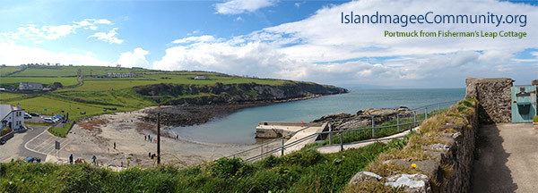 | ||
Islandmagee whitehead i northern ireland
Islandmagee (from Irish: Oileán Mhic Aodha, meaning "Magee’s island/peninsula") is a peninsula and civil parish on the east coast of County Antrim, Northern Ireland, located between the towns of Larne and Carrickfergus. It is part of the Mid and East Antrim Borough Council area and is a sparsely populated rural community with a long history since the mesolithic period. In the early medieval period it was known as Semne, a petty-kingdom within Ulaid.
Contents
- Islandmagee whitehead i northern ireland
- Map of Island Magee Larne UK
- History
- Archaeology
- Sport
- Civil parish of Island Magee
- Townlands
- References
Map of Island Magee, Larne, UK
As part of an agricultural crop rotation programme of old beans were grown to supply nitrogen to the soil. "Bean Eaters" became a nickname for the people of Islandmagee.
It is the site of Northern Ireland's main power station Ballylumford and is the terminating point of the Scotland-Northern Ireland gas pipeline.
History
The name comes from Mac Aodha (Magee) a prominent Irish family in the area. An earlier Irish name was Rinn Seimhne (peninsula of (the district of) Seimhne) from an original tribal name.
The Bissett family held the tenancy of the peninsula in Elizabeth I's reign, their rent being an annual offering of goshawks, birds which bred on the rugged white chalk cliffs nearby. It was the site of a witch trial in 1710 where eight women were convicted of witchcraft and sentenced to a year's imprisonment.
Archaeology
Sport
Civil parish of Island Magee
The peninsula is part of the parish of Island Magee. The boundaries of the parish and the peninsula match.
Townlands
The civil parish contains the following townlands: