
Gaelic name Eilean MhicAsgain Area rank 199= Area 50 ha | OS grid reference NR786994 Highest elevation 65 m Council area Argyll and Bute | |
 | ||
Island groups British Isles, Inner Hebrides | ||
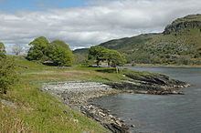
Island Macaskin or MacAskin (Scottish Gaelic: Eilean MhicAsgain) is an island in Loch Craignish, in the Inner Hebrides of Scotland.
Contents
Map of Island Macaskin, United Kingdom
History and wildlifeEdit
The island was formerly inhabited, and unusually for the Scottish islands, is quite well wooded, with some mature trees scattered about. It appears to have been abandoned in the 1880s, but there is ample evidence of human habitation on it, including a number of walls, a sheep pen, and a lime kiln.
A number of wild flowers grow here, though not as many as on nearby Eilean Rìgh.
Geography and geologyEdit
The island is long and narrow, aligned SW-NE, parallel to the nearby shore of the mainland. It is basically a ridge, with the west being higher than the east. The western side is dominated by the steep sides to the islands central ridge that reaches a height of 65 metres (213 ft). A line of skerries extend from the south of the island into the Sound of Jura.
The geology is metamorphic apidiorite with some Dalriadan quartzite at the south end.
It is surrounded by various smaller islands including Eilean nan Gabhar, Eilean nan Coinean, Garbh Rèisa, Rèisa an t-Sruith, Rèisa MhicPhàidein and Eilean na Cille.