
Elevation 334 m Area code 705 | ||
 | ||
- summer (DST) Eastern Time Zone (UTC-4) Municipality Unorganized North Algoma District | ||
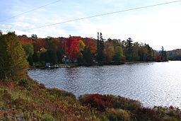
Island Lake is a settlement in the Unorganized North Part of Algoma District in northeastern Ontario, Canada. It is part of the Aweres local services board and is about 5 kilometres (3 mi) northeast of the community of Heyden on Ontario Highway 17. The settlement is at the junction of Ontario Highway 552 and Ontario Highway 556, and the Algoma Central Railway passes through the community.
Map of Island Lake, ON, Canada
Island Lake lies on the shores of Upper Island Lake and Lower Island Lake; the Upper Island Lake Dam controls the flow from the former to the latter, and the waters flow via the Root River to the St. Marys River.
References
Island Lake, Algoma District Wikipedia(Text) CC BY-SA