
Year first constructed 1940 (first) Markings / pattern red lantern Focal height 63 m Range 22,224 m | Construction steel skeletal tower Light source solar power Height 22 m | |
 | ||
Location Isla del CañoOsaCosta Rica Tower shape square pyramidal skeletal tower Similar Bahía Drake, Corcovado National Park, Marino Ballena National, Manuel Antonio National, Tortuguero National Park | ||
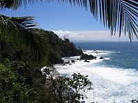
Isla del Caño is a small island in the Bahia de Corcovado (Corcovado Bay) in Osa Costa Rica. It is on the Pacific Ocean side of Costa Rica, 10 miles (16 km) west of Punta Llorona on Península de Osa. It rises steeply to a flat top of 123 metres (404 ft) in height.
Contents
Map of Isla del Cano, Costa Rica
Caño Island National Park has been established as a protected national park as a part of the Osa Conservation Area, with a permanent ranger station on the island. It is a popular tourist destination for ecotourism such as whale watching, attracting visitors for its beaches, coral beds, and sea life. Researchers currently use the coral beds to study the factors surrounding coral death and recolonization. Marine life includes manta rays, dolphins, sea turtles, whales, awide variety of fish, and possibly manatees as well. The limited diversity of terrestrial fauna, however, is noticeable, with the island having less than one percent of the insect diversity of the peninsula and an absence of numerous animals native to the nearby mainland. Evidence of pre-Columbian human activity on the island is substantial, with some of the most interesting artifacts being stone spheres evidently carved by early civilizations.