
Country Germany District Hanover Time zone CET/CEST (UTC+1/+2) Area 59.72 km² Postal code 30916 | State Lower Saxony Elevation 58 m (190 ft) Postal codes 30916 Population 22,846 (31 Dec 2008) Local time Thursday 12:44 AM | |
 | ||
Weather 5°C, Wind W at 6 km/h, 77% Humidity | ||
Isernhagen is a municipality in the district of Hanover, in Lower Saxony, Germany. It is situated in the north-east of Hanover. According to the average income per capita it is the most affluent municipality in Lower Saxony. Bundesautobahn 7 passes through the municipality.
Contents
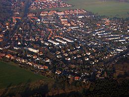
Map of Isernhagen, Germany
Division of the municipality
Isernhagen consists of 7 districts:
Gartenstadt Lohne is part of Neuwarmbüchen.
Twinned with Peacehaven in East Sussex, Épinay-sous-Sénart in France, Suchy Las in Poland and Tamási in Hungary.
References
Isernhagen Wikipedia(Text) CC BY-SA