
First ascent Unknown Elevation 1,284 m | Mountain range Drakensberg | |
 | ||
Similar Popple Peak, Cathedral Peak, Spion Kop, Njesuthi, Drakensberg | ||
Isandlwana battlefield south africa gohop ie unravel travel tv
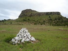
Isandlwana ([ísanˈdɮwáːna]) (older spelling Isandhlwana, also sometimes seen as Isandula) is an isolated hill in the KwaZulu-Natal province of South Africa. It is located 105 miles (169 km) north by northwest of Durban.
Contents
- Isandlwana battlefield south africa gohop ie unravel travel tv
- Map of Isandlwana Nhloya South Africa
- History
- References
Map of Isandlwana, Nhloya, South Africa
History
This mountain has historical significance. On 22 January 1879, Isandlwana was the site of the Battle of Isandlwana, where approximately 22,000 Zulu warriors defeated a contingent of approximately 1,350 British and Native troops in one of the first engagements of the Anglo-Zulu War. The force was largely wiped out by the Zulus under Ntshingwayo kaMahole Khoza. The battle remains the single greatest defeat for the British Army at the hands of a native army.
Isandlwana hill rises 10 miles (16 km) southeast of Rorke's Drift, a ford on the Buffalo River, a tributary of the Tugela River.