
Country India District Wayanad PIN 673579 Literacy 95% ISO 3166 code ISO 3166-2:IN | State Kerala Time zone IST (UTC+5:30) Vehicle registration KL- Population 21,111 (2001) Nearest city Pulpally | |
 | ||
3acre land with house for sale in near irulam wayanad
Irulam is a village near Pulpally in Wayanad district in the state of Kerala, India.
Contents
- 3acre land with house for sale in near irulam wayanad
- Map of Irulam Kerala
- Demographics
- Main places in Irulam
- Economy
- Transportation
- References
Map of Irulam, Kerala
Demographics
As of 2001 India census, Irulam had a population of 21111 with 10637 males and 10474 females.
Main places in Irulam
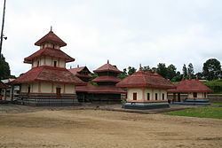
SeethaDevi Lava Kusha Temple, Chathamangalam Kunnu, Angadishery, Ambalapadi, Irulam Church, Irulam Mosque [Beside of Irulam Government High School], Irulam GHS
Economy
The main crops in the village are pepper, coffee, caradamom, paddy and ginger.
Transportation
Irulam village is near Pulpally town which can be accessed from Mananthavady or Kalpetta. The Periya ghat road connects Mananthavady to Kannur and Thalassery. The Thamarassery mountain road connects Calicut with Kalpetta. The Kuttiady mountain road connects Vatakara with Kalpetta and Mananthavady. The Palchuram mountain road connects Kannur and Iritty with Mananthavady. The road from Nilambur to Ooty is also connected to Wayanad through the village of Meppadi.
The nearest railway station is at Mysore and the nearest airports are Kozhikode International Airport-120 km, Bengaluru International Airport-290 km, and Kannur International Airport, 58 km.