
 | ||
The Iron Triangle (Vietnamese:Tam Giác Sắt) was a 120 square miles (310 km2) area in the Bình Dương Province of Vietnam, so named due to it being a stronghold of Viet Minh activity during the war. The region was under control of the Viet Minh throughout the French war in Vietnam and continued to be so throughout the phase of American involvement in the Vietnam War, despite concerted efforts on the part of US and South Vietnamese forces to destabilize the region as a power base for their enemy, the communist North Vietnamese–sponsored and–directed South Vietnamese insurgent movement, the National Liberation Front or Viet Cong (NLF).
Contents
Geography
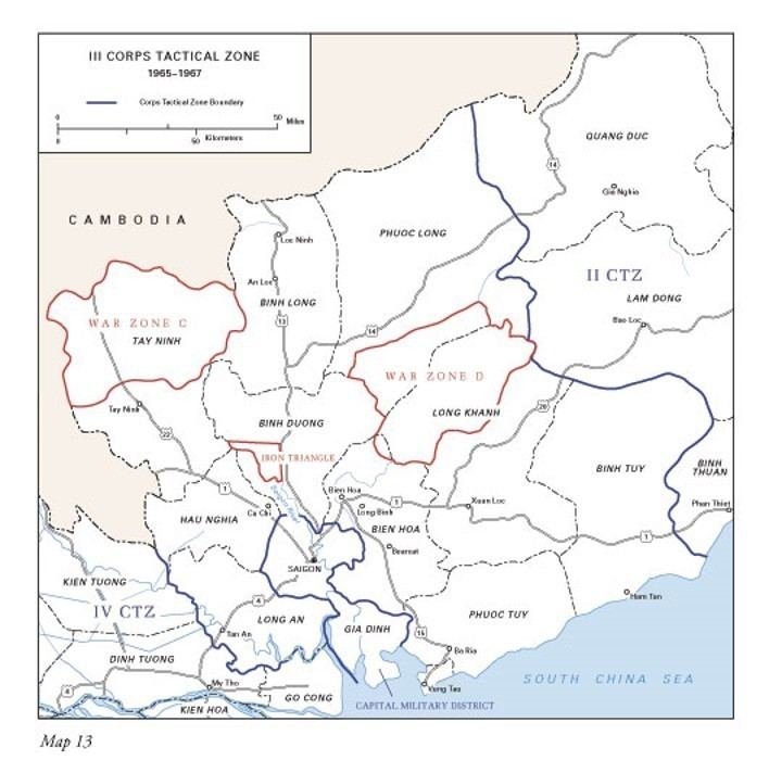
The Location of the Iron Triangle was between the Saigon River on the west and the Tinh River on the east and bordering Route 13 about 25 miles (40 km) north of Saigon. The southern apex of the "triangle" was seven miles (11 km) from Phu Cong, the capital of Bình Dương Province. Its proximity to Saigon was both a reason for American and South Vietnamese efforts to eradicate it, as well as why it remained a crucial area for Communist forces to control.
The French War
During the French war in Indochina, from 1946 to 1954, the Viet Minh elaborated on a network of hidden fortifications and tunnels throughout the region to defend themselves against the superior military power of the French. These tunnel networks had begun as early as the 1880s to resist French occupation. The network afforded communist fighters the ability to "disappear" into the countryside. This became especially important during the Vichy Regime, when Vietnam was dually occupied by French and Japanese forces, so as to remain undetected by not one but two occupying enemies.
The American War
The tunnels were expanded further after the war with the French as a base for underground operations against the Ngo Dinh Diem government and later US-backed South Vietnamese governments. The tunnel system at its height was said to have over 30,000 miles (48,000 km) of tunnels throughout North and South Vietnam, with hundreds of miles of these located in the Iron Triangle, especially concentrated in the area around the town of Cu Chi. Due to the threat that the Củ Chi tunnels posed to the Saigon government, the United States stepped up its military offensive in the region in the fall of 1966 and 1967. They launched three operations during this time: Operation Attleboro, Operation Cedar Falls, and Operation Junction City. Operation Cedar Falls was an especially intensive attack involving nearly 16,000 American troops and 14,000 soldiers of the South Vietnamese Army. The operation took nineteen days, and 72 Americans and 720 Viet Cong were killed. Despite their massive attack with B-52 bombers and Rome plows and efforts to destroy the tunnel system with explosives, flooding, and "tunnel rats" (specially trained soldiers who would infiltrate the tunnels armed only with a flashlight and a handgun), the Americans failed to totally destroy the Viet Cong support system that had been built for over two decades.
The Iron Triangle at the end of the Vietnam War
The area remained an active organizing center for the Viet Cong right through to the end of the war, due to both its undeniable strategic importance, as well as support from local populations who had been negatively impacted by the American bombing campaign. In April 1975, General Văn Tiến Dũng, political bureau members Phạm Hùng and Lê Đức Thọ, and southern military commander Trần Văn Trà all joined together in the Iron Triangle region to orchestrate the final, decisive attack on Saigon. The area had remained allied with the nationalist communist forces from the beginning of the French war in 1946 to the fall of Saigon in 1975: an exception in a country often torn region by region between control by American forces and control by the Viet Cong.