
Postal code 843 00 Website www.iraklia.gr Area code 22870 | Time zone EET (UTC+2) Vehicle registration EM Max length 7 km Island group Cyclades | |
 | ||
Irakleia or Heraklia (Greek: Ηρακλειά) is an island and a former community in the Cyclades, Greece. Since the 2011 local government reform it is part of the municipality Naxos and Lesser Cyclades, of which it is a municipal unit. Its population was officially 141 inhabitants at the 2011 census, and its land area 17.795 square kilometres (6.9 sq mi). It is a small island between the islands of Naxos and Ios. In close proximity to Schoinoussa, Koufonisi, Donoussa, and Keros islands, together they form the Small Cyclades. The port is called Agios Georgios, while the "capital"/chora on the top of the island is called Panagia (Madonna). The biggest caves in the Cyclades are located on Irakleia. Irakleia can be reached by ferries from Athens, Naxos and Paros.
Contents
Map of Irakleia, Iraklia 843 00, Greece
Description
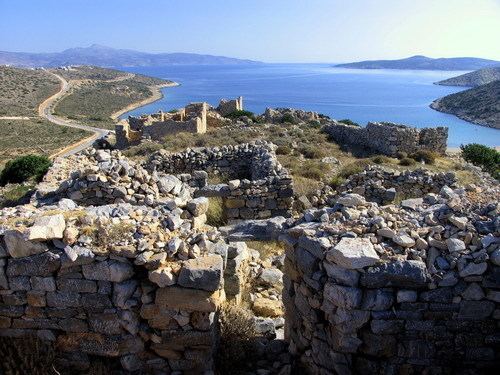
Iraklia is the largest island of the Lesser Cyclades. It is located in the east part of the archipelago, south of Naxos. The island has two settlements, Panagia in the middle of the island and Agios Georgios, where the port is located. Irakleia has been inhabited from early antiquity. On the island there are many mysterious rock paintings dated about 5,000 years before. The paintings, named Bousoules (Μπούσουλες), may have been used as orientation marks. The ruins of a fortress dating from the 4th-2nd century B.C. are located at Livadi on the island. In modern times, Iraklia was the property of the Hozoviotissa Monastery on the nearby island of Amorgos.