
Population 70 Post town MALLAIG Local time Tuesday 11:01 PM Lieutenancy areas Highland, Inverness | OS grid reference NG766000 Sovereign state United Kingdom Postcode district PH41 Dialling code 01687 | |
 | ||
Weather 7°C, Wind W at 34 km/h, 78% Humidity Scottish parliaments Highlands and Islands, Inverness East, Nairn and Lochaber | ||
Mallaig to inverie scotland
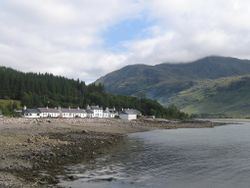
Inverie (/ˌɪnvəˈriː/; Scottish Gaelic: Inbhir Aoidh) is the main village on the peninsula of Knoydart in the Scottish Highlands and is concentrated on the north side of Loch Nevis. Although on the mainland of Britain, the few miles of single-track road are not connected to the rest of the national road network. Inverie is only reachable, aside from a 17-mile (27 km) hike over very rough terrain, by a regular 7-mile (11 km) ferry from Mallaig, giving the place a Guinness National Record for remoteness.
Contents
- Mallaig to inverie scotland
- Map of Inverie Mallaig UK
- Paddle steamer waverley sailing to inverie 28 05 14
- Geography
- Amenities
- References
Map of Inverie, Mallaig, UK
Paddle steamer waverley sailing to inverie 28 05 14
Geography
Inverie lies on the north side of Loch Nevis. On approach by sea, Sgurr Coire Choinnichean at 769m (2,522 ft) forms an impressive backdrop.
The Inverie ferry, the Knoydart-based Knoydart Seabridge, sails from Mallaig; it runs several times a day year-round, including weekends. A rival ferry service, the MV Western Isles, operates Monday to Friday from the start of April to the end of October.
Amenities
The Old Forge pub here is, accordingly, the remotest pub in mainland Britain being furthest from roads connected to the national network in time and journey distance
A few bed and breakfasts compete with rental lodges, cottages and a campsite for tourists' custom throughout the year. In addition to the pub, there are two cafes, a shop, and a pottery.