
Existed: 2011 (2011) – present Counties: Guilford Length 9.29 km | Constructed 2011 | |
 | ||
East end: I‑40 / I‑85 / I‑85 Bus. in Greensboro County | ||
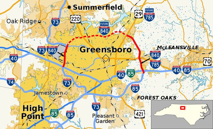
Interstate 840 (I-840) is an Interstate Highway in the U.S. state of North Carolina. It is currently in two sections traversing 5.77 miles (9.29 km) total in Guilford County; when completed, it will form the northern section of the Greensboro Urban Loop.
Contents
Map of I-840, Greensboro, NC, USA
Route description
I-840 currently exists in two segments that will eventually form the northern bypass around Greensboro.
The western segment, a divided six-lane urban freeway, begins at the interchange of I-40/I-73/US 421 and goes north for 3.56 miles (5.73 km) to Bryan Boulevard, where it terminates. Currently, this segment is signed as "Future" because it does not reconnect to another U.S. Route or Interstate; however, it has been a federally recognized interstate since 2011 despite the current banner. The entire route is in concurrency with I-73.
The eastern segment, a divided four-lane rural freeway, begins at US 70 (Burlington Road) and goes south for 2.21 miles (3.56 km) to the I-40/I-85/I-85 Bus interchange, its eastern terminus. The entire route is in concurrency with I-785. The eastern segment is currently unsigned with plans of it remaining as a hidden designation for I-840 until it connects with the western segment.
Both sections have a maximum speed limit of 65 miles per hour (105 km/h).
History
I-840 first appeared in the early 2000s as a proposed routing for the northern half of the Greensboro Urban Loop. In 2002, the first segment opened between US 70 and I-40/I-85; however, it was unsigned and designated as SR 3269; by 2006, Future I-840 signage was added at the US 70 interchange. In December 2007, a second segment opened along its routing between I-40/US 421 and Bryan Boulevard and was signed as Future I-73/I-840. In 2010, NCDOT submitted its official request, to both the AASHTO and the FHWA, to designate the two existing segments of the northern half of the Greensboro Urban Loop as I-840 and the 15.26-mile (24.56 km) unbuilt portion as Future I-840. AASHTO approved the request on October 29, 2010 followed by FHWA on August 2, 2011. On September 2, 2011, NCDOT certified the route change establishing I-840.
Construction on the northern half of the Greensboro Urban Loop resumed in 2013 with the 3.8-mile (6.1 km) segment, between Bryan Boulevard and Battleground Avenue (US 220), which will be signed as I-840. In late 2014, a 5.5-mile (8.9 km) segment, between US 29 and US 70, also began construction; however, it will be signed as I-785 with I-840 as a hidden designation.
Future
As of 2014, there are four segments of the northern half of the Greensboro Urban Loop to be completed.
Segments along the western loop will be designated as I-840 upon opening; segments along the eastern loop will have a hidden I-840 designation until it joins with the western loop, fully designating the entire northern half of the Greensboro Urban Loop. Long term plans call for two additional interchanges along I-840: Fleming–Lewiston Road (SR 2136) and Cone Boulevard (SR 2565). Plans for both interchanges have existed since 2004; however, because both are to be constructed after the I-840's completion, there is no current time table or funding for these two projects at this time.
Exit list
The entire route is in Greensboro, Guilford County.