
Existed: 1956 – present Constructed 1956 | Length 131.4 km | |
 | ||
West end: I-71 / US 224 near Lodi East end: I-76 / Penna Turnpike at Pennsylvania state line | ||
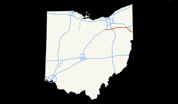
In the U.S. state of Ohio, Interstate 76 (I-76) runs for 82 miles (132 km) from Interstate 71 south of Cleveland to the Pennsylvania state line south of Youngstown. Once numbered Interstate 80S, Interstate 76 now comprises the easternmost leg of the Ohio Turnpike.
Contents
Route description
The western terminus of Interstate 76 is at an interchange with Interstate 71 east of Lodi, cosigned with U.S. Route 224. U.S. 224 continues west from that point as a regular road. From the interchange with I-71, I-76 crosses rural eastern Medina County and the southeastern Summit County cities of Barberton and Norton for 18 miles (29 km), cosigned with U.S. 224. The eastern terminus of the concurrency with U.S. 224 is in southwestern Akron, at an interchange with Interstate 277, the southern bypass of Akron. Between mile markers 18 and 20, I-76 runs north-south as part of a section known as the Kenmore leg, before returning to an east-west alignment. The route runs concurrently with Interstate 77 for approximately 3 miles (4.8 km) in central Akron, between mile markers 20 and 23, with eastbound traffic joining southbound I-77 traffic. The eastern end of the concurrency with I-77 is at an area known as the central interchange, with southbound I-77 traffic exiting towards Canton. The interchange also serves as the southern end of State Route 8.
Between the Akron and Youngstown areas, Interstate 76 passes through rural areas of southern Portage County near Kent and Ravenna, and western Mahoning County. West of Youngstown in Jackson Township, it intersects with Interstate 80 and the Ohio Turnpike in a double trumpet interchange. Interstate 76 eastbound traffic exits the freeway alignment to join the Ohio Turnpike, with westbound traffic exiting the toll road. I-76 eastbound travelers who remain on the freeway alignment transfer to Interstate 80 towards New York City via the Keystone Shortway, while westbound traffic remains on the turnpike as part of I-80 towards Cleveland. Between the interchange with I-80 and the Pennsylvania state line, Interstate 76 is part of the Ohio Turnpike in a southeast-northwest alignment for 21 miles (34 km) and connects with the Pennsylvania Turnpike at the Pennsylvania–Ohio state line. Though I-76 does not pass through the city of Youngstown, access is provided via exits to I-80, I-680, and State Route 7. As of 2016, the toll to travel the Interstate 76 portion of the Ohio Turnpike is $1.75. Motorists who use E-ZPass pay a discounted rate of $1.
Interstate 76 / US 224 Alt
Interstate 76 / US 224 Alt is the designation of a route in Summit County. The route follows SR 21 northbound from I-76 in Norton, then follows I-77 southbound in Copley Township. The route terminates at I-76 in Akron. Signage exists along the route but it is not recognized in the Ohio Department of Transportation's records.