
Existed: 1975 – present Constructed 1975 | Length 61.2 km | |
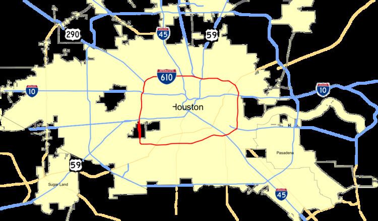 | ||
Interstate 610 (abbreviated I-610) is a freeway that forms a 38-mile-long (61 km) loop around the downtown sector of city of Houston, Texas. Interstate 610, colloquially known as The Loop, Loop 610, The Inner Loop, or just 610, traditionally marks the border between the inner city of Houston ("inside the Loop") and its surrounding areas. It is the inner of the three Houston beltways, the other two being Beltway 8 (Sam Houston Tollway) and State Highway 99 (Grand Parkway), of which various segments are under construction or planning. It is one of four interstate loops not to share its route with another interstate freeway, the others being I-270, I-295, and I-485.
Contents
Map of I-610, Houston, TX, USA
In Houston the area inside the 610 Loop is the urban core. Jeff Balke of the Houston Press wrote that the freeway "is as much a social and philosophical divide as a physical one."
Route description
Major segments of Interstate 610 are known as the North Loop, the South Loop, the East Loop, and the West Loop. The North Loop runs from U.S. Highway 290 to U.S. Highway 90. The East Loop runs from Highway 90 to State Highway 225. The West Loop runs from Highway 290 to the South Post Oak Road spur, and the South Loop runs from South Post Oak Road to Highway 225. Sometimes, a direction name is added as a suffix to denote a more specific part of a portion of the loop and this does not denote the direction of traffic flow. For example:
Lane configurations
Starting at U.S. Highway 290, moving in a clockwise direction, mainlane counts are as follows:
History
The concept of building a bypass highway around Houston was first proposed in 1931, but plans did not begin to formalize until 1941. The loop was initially proposed to transport troops and materials around the city. On May 3, Harris County voters approved a bond to build the "Defense Loop". It was officially designated as Loop 137 in 1942, and the North Loop was approved by the Texas Transportation Commission. World War II delayed construction of the Loop until the 1950s.
In July 1953, the city of Houston asked the Texas Transportation Commission to include 2 new sections of Loop 137 (the West Loop and the South Loop) as part of the state's highway system. It was initially rejected, but in October 1954, the North Loop was upgraded to a freeway, and the West and South Loops were approved as freeways.
When the Interstate Highway system was authorized in 1956, the then C-shaped Loop 137 (now designated Interstate 610) was adopted into the plan. The East Loop would not be approved until 1960. That segment was finished in 1973 with the opening of the Sidney Sherman Bridge over the Houston Ship Channel.
Construction on the North Loop began in 1950. Construction was sporadic throughout the 1950s and 1960s. It was completed in 1976 with the interchange that connects Loop 610 to Interstate 10 east of Houston.
In the early 1990s, TxDOT proposed a widening project for the West Loop, which at the time was the busiest freeway in Houston. One of the proposals was for a dual-dual freeway with a total of 24 lanes in some places, which would have made it the widest freeway in the world. Amid vocal opposition and little apparent support, the plans for expansion were cancelled.
In the late 1990s, the need to repave and reconstruct portions of the West Loop became evident. The reconstruction project was approved, but only as a "no-capacity-added" project; only safety and structural improvements could be made. However, some Houston residents have noted that merging lanes and exit ramps are particularly long and in effect, serve as additional lanes.
As of 2014, the segment of the West Loop from the Katy Freeway to the Southwest Freeway is ranked by TxDOT as the most congested roadway in the state, based on annual hours of delay per mile.
Exit list
The entire highway is in Harris County.